
Gulperberg is a climb of 1.8 kilometers (category 4). The climb finishes at 159 m above sea level. It is located in Gulpen, Limburg, Nederland. The average gradient is 3.5% with a maximum of 17.4%. The climb has 63 meters of elevation gain.
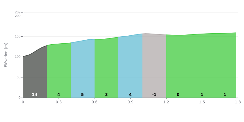
Difficulty analysis: At 1.8 km for 63 m of elevation gain and an average gradient of 3.5%, the Gulperberg rates as a Cat 4 climb, a moderate but demanding effort. The real challenge is at the start: the KM 0.0-0.2 section averages 13% over 215 m, which means 28 m of climbing in that stretch alone, almost half the total. After that, the road alternates between 3% and 4% up to KM 1.0, then becomes nearly flat, even slightly downhill, for the second half of the climb.
Tips for pacing yourself:
1. Ease into the wall. On the KM 0.0-0.2 stretch at 13%, stay seated, choose an easy gear and avoid attacking out of the saddle so you don't blow up before the real climbing begins.
2. Find a steady rhythm on the 3-4% slopes. Between KM 0.2 and 1.0, hold a smooth cadence and a constant effort, and don't go chasing the riders ahead too early.
3. Recover, then ramp it up at the end. Between KM 1.0 and 1.8, where the gradient varies between -2% and 1%, use the flatter section to catch your breath, then gradually build your pace all the way to the summit.
Those who have climbed the Gulperberg talk first about the view. From the Maria monument at the top, you can see the hills of southern Limburg, the green fields, the small villages and the roads winding between them. Several people name Gulpen, Wittem, Partij or Wijlre, and some say they can make out Germany and Belgium. Sunsets come up often, and many people have come specifically to photograph them.
On the effort side, the reports are straight up. The climb is steep, the little roads are narrow, and you need good legs to get to the top. One rider finds the gradient not steep enough, but that's a lone opinion. Someone suggests, in peak season, leaving the car at the nature park-and-ride at the bottom and finishing on foot, since the road is busier at that time.
Once at the summit, you can take a break. There are benches and picnic tables, a park laid out around the monument, and a free car park, although there aren't many spaces. Some people have a barbecue in the small neighbouring park, where designated spots are provided. A restaurant is about 200 metres away, and the village at the foot of the hill has a few shops. There are no toilets on site, and shade is scarce, so it's best to avoid very hot days.
The negatives come up too. Several people find the monument under-maintained and the green space neglected. Litter is still lying around in places. The hiking trails are sometimes poorly marked, with signposts missing, which can worry someone who doesn't know the area. One witness also notes that the campsites nearby don't all make the most of the view.
Despite all this, the atmosphere is calm. People describe a place where you stay a while, taking in the scenery, with fresh air and, at times, sheep grazing in the meadow below. For the cyclist, it's a climb that has to be earned, with a great reward at the top.
1.8 km • 63 m D+
VAM: average climbing speed, based on elevation gain


Join thousands of cycling fans! Plan your rides, record your performance, track your progress and discover the finest climbs.
Live climb profile to pace your effort all the way to the top.


Within 20 km