
Mirador de Los Andenes is a climb of 30.1 kilometers (hors catégorie). Mirador de Los Andenes tops out at 2,297 m above sea level. It is located in Garafía, n/a, España. The average gradient is 7.2% with a maximum of 14%. The climb has 2161 meters of elevation gain.
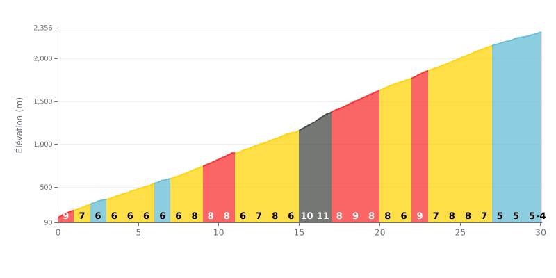
Difficulty analysis: A demanding beyond-category (HC) climb over 30.1 km. The difficulty lies in its length and its consistently steep profile, with a brutal stretch between km 15 and 22 (gradients of 10% and 11%) that forms the hard core of the climb. The final section is slightly easier, at around 5%, but accumulated fatigue will be the deciding factor.
Effort management tips:
1. Pacing: Start conservatively to save your legs. The significant increase in gradient after km 15 calls for steady power, so avoid surges.
2. Prepare for the crux: Km 15 to 22 (8% to 11%) are the decisive kilometres. Tackle them with a suitable gear ratio and a smooth, consistent cadence to avoid blowing up early.
3. Make the most of the easier finish: The last kilometres (5%) give you a chance to pick up the pace if you've managed your effort well. Keep turning the pedals over to finish strong.
For cyclists who have climbed the Mirador de Los Andenes, the ascent is described as a demanding but unforgettable challenge, on a winding road (LP-4) with countless hairpin bends. Riders' accounts speak of a long, physically punishing climb where every bend is a new test, but the effort is more than repaid at the top.
The reward matches the challenge: a spectacular, panoramic view over the Caldera de Taburiente on one side and, on a clear day, the ocean and neighbouring islands on the other. Riders talk about the unique feeling of riding above the clouds, with a "sea of clouds" below them. The atmosphere is that of a lunar, wild landscape, "une dzicz nietknięta ludzka ręką" (untouched wilderness), which contrasts with the denser vegetation you pass lower down.
Riders also stress some specific conditions to plan for. Parking at the summit is very limited, which can lead to a fair amount of crowding. The weather is also a crucial factor: it can be very cold and windy above 2000 metres, even in summer, and the summit can be swallowed by cloud, blocking the view completely. Take care on the descents, especially if the road is wet or icy.
The experience is about more than just the effort and the scenery. Riders mention curious wildlife, with bold ravens that hang around the viewpoint. For many, the most magical moment is watching the sunset, or staying the night up there to take in an exceptionally clear starry sky, which makes this climb much more than just a bike ride.
30.1 km • 2161 m D+
VAM: average climbing speed, based on elevation gain


Join thousands of cycling fans! Plan your rides, record your performance, track your progress and discover the finest climbs.
Live climb profile to pace your effort all the way to the top.


Within 20 km