
Thinsrine is a climb of 10.2 kilometers (hors catégorie). Thinsrine tops out at 992 m above sea level. It is located in El Main ⵉⵍⵎⴰⵢⴻⵏ الماين, Bordj Bou Arreridj, Algérie ⵍⵣⵣⴰⵢⴻⵔ الجزائر. The average gradient is 7.5% with a maximum of 18.7%. The climb has 766 meters of elevation gain.
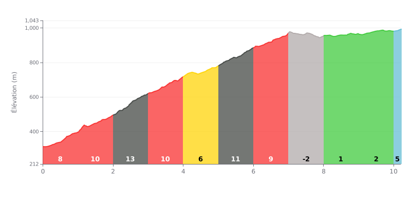
Difficulty breakdown: The Thinsrine from Aguemoun-n-Aït Aïssa is a beyond category (HC) climb of 10.2 km with 766 m of elevation gain, at an average gradient of 7.5%. The effort is sustained from the start, with gradients between 6% and 13% over the first seven kilometres, the steepest section sitting between km 2.0 and km 3.0 at 13%. The stretch from km 7.0 to km 10.0, where the gradient varies between -2% and 2%, gives you a breather before a 5% finish over the last 200 metres. The difficulty lies mostly in the length of the climb and the uneven, changing gradients that gradually wear you down.
Tips for pacing yourself:
1. Save your legs at the start: Don't go out too hard on the 8% section from km 0.0 to km 1.0, so you have something left for the 13% ramp between km 2.0 and km 3.0.
2. Recover on the flat: Use the km 7.0 to km 10.0 section, where the gradient stays close to zero, to drink, eat and find a steady rhythm before the final push.
3. Hold a controlled finish: Take the 5% from km 10.0 to km 10.2 in a suitable gear with a steady cadence, and don't sprint too early, so you reach the summit with plenty left in the tank.
10.2 km • 766 m D+
VAM: average climbing speed, based on elevation gain


Join thousands of cycling fans! Plan your rides, record your performance, track your progress and discover the finest climbs.
Live climb profile to pace your effort all the way to the top.

