
Mount Pulag is a climb of 11.0 kilometers (hors catégorie). Mount Pulag tops out at 2,498 m above sea level. It is located in Eddet, Benguet, Philippines. The average gradient is 13.6% with a maximum of 19.7%. The climb has 1505 meters of elevation gain.
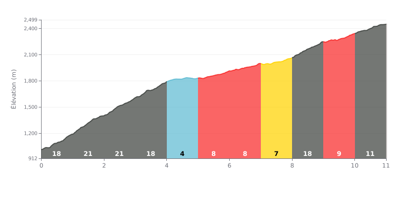
Difficulty analysis: With 11 km for 1,505 m of elevation gain and an average gradient of 13.6%, Mount Pulag from Beleng is a beyond-category (HC) climb. The first 4 km are particularly punishing, with gradients of 18 to 21%. The 4-5 km section, at just 4%, offers a real breather before a series of pitches between 7 and 11% up to the 8 km mark. The 8-9 km section, at 18%, is then the toughest part of the second half.
Tips for the effort:
1. Pace the start. The first 4 km hit 18 to 21%, so stay below your threshold and don't blow up right from the foot of the climb.
2. Make the most of the 4-5 km flat. At 4%, this section is your chance to recover, catch your breath, and eat or drink before what's next.
3. Save something for the 8-9 km ramp. This 18% kick comes when your legs are already taxed, so hold a steady rhythm through it, then manage the final 9-11 km at 10 to 11%.
According to those who have climbed it, the ascent of Mount Pulag is an experience that leaves a lasting impression. The sight of the sunrise above a sea of clouds is described as absolutely magical, a "surreal" landscape that is "breathtaking" and makes every effort worth it. Many talk about a feeling of euphoria and gratitude once at the summit, calling it "the playground of the gods".
The approach to the mountain itself is an adventure. The road to the starting point in Kabayan, Benguet, is described as winding and potentially nausea-inducing. Riders also need to be ready for regulated logistics: booking in advance is mandatory, as is a medical certificate, a fee of about 850 PHP for foreigners, and a local guide.
The condition of the trail, especially the most popular one (Ambangeg), depends heavily on the weather. In rain, it becomes extremely muddy and slippery, making progress difficult, even on a route considered "easy for beginners". The elevation gain is gradual, but the hike, which often starts around 2 AM to reach the summit at dawn, requires good fitness. Several reports recommend some training beforehand.
The most striking element for almost everyone is the intense cold, especially while waiting for the sun at the summit. Temperatures can get close to 0°C, and the wind is often fierce. Accounts stress the need for warm clothing, "winter gear" style, and several layers. The experience can be grueling, but everyone agrees that the beauty of the landscape makes every hardship worth it.
Finally, a strong environmental awareness comes through in the shared experiences. Hikers are urged to be respectful visitors: leave no trace, don't litter, and protect this sacred site for the local communities. Some also lament the overcrowding on weekends, which can spoil the peacefulness of the place.
11.0 km • 1505 m D+
VAM: average climbing speed, based on elevation gain


Join thousands of cycling fans! Plan your rides, record your performance, track your progress and discover the finest climbs.
Live climb profile to pace your effort all the way to the top.


Other climbs to Mount Pulag
Within 20 km