
Mount Nangaoto is a climb of 6.6 kilometers (hors catégorie). The climb finishes at 2,517 m above sea level. It is located in Natubleng, Benguet, Philippines. The average gradient is 13.8% with a maximum of 18.1%. The climb has 912 meters of elevation gain.
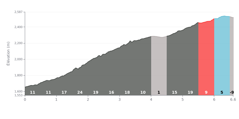
Difficulty breakdown: With 6.6 km, 912 m of elevation gain and an average gradient of 13.8%, Mount Nangaoto is a particularly punishing HC climb. The first 3.5 km never drop below 10%, with a 24% ramp between 1.5 and 2.0 km that is the hardest point of the climb. The 4.0 to 4.5 km section, almost flat at 1%, gives you too short a breather to really recover before a second half just as steep, especially between 5.0 and 5.5 km at 19%. The effort is long, uneven and has no real rest stop.
Tips for pacing yourself:
1. Don't go out too hard. The first two kilometres at 11% look manageable, but save something for the 1.0 to 3.5 km section where the gradient climbs between 17% and 24%.
2. Manage your effort between 1.5 and 2.0 km. On this 24% ramp, keep a smooth cadence and a steady rhythm, and stay seated to save your legs.
3. Make the most of the 4.0 to 4.5 km flat. Use this 1% stretch to drink, take on food and get your breathing back before tackling the series of steep sections between 4.5 and 5.5 km.
6.6 km • 912 m D+
VAM: average climbing speed, based on elevation gain


Join thousands of cycling fans! Plan your rides, record your performance, track your progress and discover the finest climbs.
Live climb profile to pace your effort all the way to the top.

