
Malý Šturec is a climb of 8.0 kilometers (category 2). The climb finishes at 888 m above sea level. It is located in Dolný Harmanec, Banskobystrický kraj, Slovensko. The average gradient is 4.9% with a maximum of 9.9%. The climb has 391 meters of elevation gain.
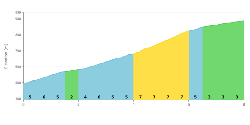
Difficulty breakdown: With 8 km for 391 m of elevation gain and an average gradient of 4.9%, the Malý Šturec is a steady Category 2 climb. There's no truly steep section, but there's no real respite either. Km 0 to 4 sits between 5 and 6%, with an easier stretch at 2% between km 1.5 and km 2.0. The decisive part is between km 4.0 and km 6.0, where the gradient ramps up to 7-8%, before a rolling finish at 3% from km 6.5 to km 8.0.
Tips for the effort:
1. Pace yourself from the start: don't go too hard over the first kilometers at 5-6%, so you save something for the toughest part.
2. Prepare for the km 4.0 to km 6.0 section: this is where the gradient hits 7 to 8%. Keep a smooth, steady cadence and stay seated to save your legs.
3. Make the most of the easier stretches: recover and drink between km 1.5 and km 2.0 at 2%, then gradually push the pace on the 3% finish from km 6.5 to km 8.0 to finish strong.
The Malý Šturec pass sits at 890 m, on the ridge between the Velká Fatra and the Kremnické vrchy. For riders who talk about it, it's mostly a starting point. You get there by car or by the cyclobus that leaves from Banská Bystrica, then you head out towards the Skalka, or the other way towards Kráľova studňa and Krížna.
On the road, the feedback is pretty good: a quality cyclo route, described as a proper bike trasa. One rider calls it a super makačka, meaning a real grind that doesn't come easy. Nobody gives a gradient or a climb length, so I can't say how hard it is.
What comes up most is the nature around the pass: the forest, the birds, and plenty of trails heading off in several directions. The spot is also popular with hikers, on both the Fatra and the Kremnica side, with a good base for setting off on foot.
There are some less pleasant points too. One witness finds the place busy ("rušno", meaning full of people). Several crosses mark motorbike riders who died right there, which weighs heavily on the place. The summit of Malý Šturec, 250 m from the car park, has nothing special according to one hiker: the forest track gets you there in a hundred metres or so, and that's about it.
8.0 km • 391 m D+
VAM: average climbing speed, based on elevation gain


Join thousands of cycling fans! Plan your rides, record your performance, track your progress and discover the finest climbs.
Live climb profile to pace your effort all the way to the top.

