
Ain dem is a climb of 10.3 kilometers (category 1). Ain dem tops out at 750 m above sea level. It is located in Boumedfaa, Aïn Defla, Algérie ⵍⵣⵣⴰⵢⴻⵔ الجزائر. The average gradient is 5.2% with a maximum of 15.2%. The climb has 530 meters of elevation gain.
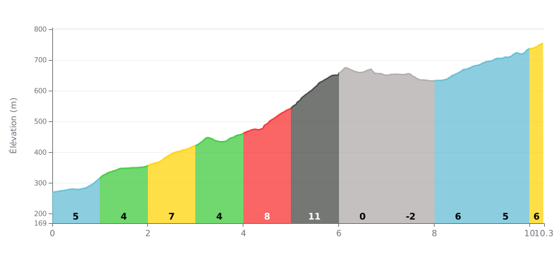
Difficulty breakdown: The Ain Dem from Tabia is a Category 1 climb, 10.3 km long, with an average gradient of 5.2% for 530 m of elevation gain. The first four kilometers, between 4% and 7%, set a stiff pace that leaves little room for error. The heart of the climb lies between km 4.0 and km 6.0, where the gradient ramps from 8% to 11%, the steepest section of the pass. The stretch from km 6.0 to km 8.0, a gentle downhill, gives you a real breather before a long, steady final section between 5% and 6% all the way to the summit.
Tips for managing your effort:
1. Pace yourself from the start. On km 0.0 to 4.0, hold a steady effort and don't go out too hard, so you reach the 11% section with fresh legs.
2. Prepare for the km 5.0 to 6.0 stretch. Shift to an easier gear before the 11% pitch, stay in the saddle and keep a smooth cadence to save your legs.
3. Recover on the descent, then settle in. Use the km 6.0 to 8.0 section to drink and loosen up your legs, then find a steady rhythm for the last kilometers at 5 and 6%.
10.3 km • 530 m D+
VAM: average climbing speed, based on elevation gain


Join thousands of cycling fans! Plan your rides, record your performance, track your progress and discover the finest climbs.
Live climb profile to pace your effort all the way to the top.


Other climbs to Ain dem