
Bukit Sipudang is a climb of 20.1 kilometers (hors catégorie). The climb finishes at 1,660 m above sea level. It is located in Boja, Jawa Tengah, Indonesia. The average gradient is 7.0% with a maximum of 21.5%. The climb has 1412 meters of elevation gain.
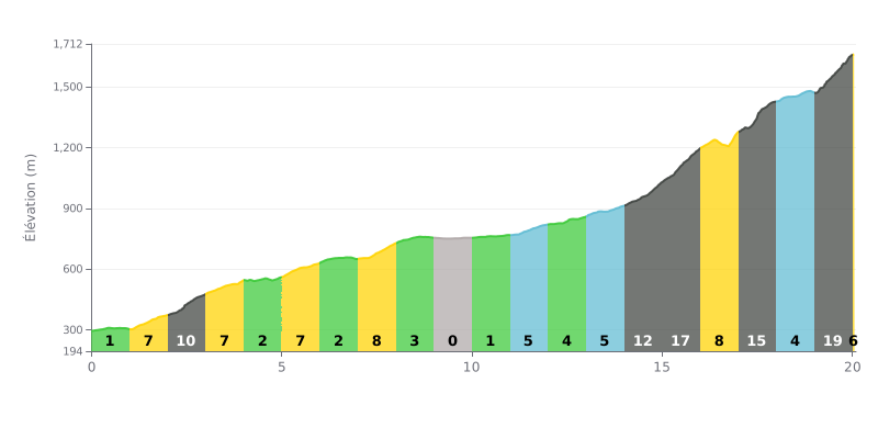
Difficulty breakdown: With 20.1 km for 1412 m of elevation gain and an average gradient of 7%, the Bukit Sipudang is a hors catégorie climb that demands a serious reserve of energy. The real test is in the final part, from km 14.0 to km 20.0, where the sections come one after another at 12%, 17%, 8%, 15%, 4% and then 19%, with no real respite. The 11% section at km 2.0-3.0 is also tough right from the start of the climb.
Pacing tips:
1. Start easy From km 0.0-1.0 at 1%, keep a steady tempo so you don't burn your matches before the 11% ramp at km 2.0-3.0.
2. Recover on the flat bits Use the 0% section at km 9.0-10.0 to drink, fuel up and loosen the legs before the second half of the climb.
3. Manage your effort in the final From km 14.0 to km 20.0, drop into your easiest gear, keep a smooth cadence and save something for the 19% wall at km 19.0-20.0.
Reviews mostly talk about the view from the lookout: you can spot Mount Prau and the city lights when the sky is clear. But the mist comes in often, and several riders went over the pass without seeing a thing. One rider did it at night in a thick fog, and another got caught in the rain on a Friday evening.
The climb is described as steep, with tanjakan (uphill sections) and turunan (descents) that demand your full attention. One rider counts three brutal ramps before you reach the rest area. The road is patchy in places, with potholes, and some find it decent, concrete and all, while others complain about the holes. Everyone stresses the state of your vehicle: check your brakes before you set off. A rescue team is on hand 24 hours a day to help road users. One rider advises small cars not to attempt the pass.
At the top, the stop is basic. A small stall serves coffee, tea, ginger, snacks and noodles, usually for around 3,000 rupiah. There are toilets, a small car park, a little flower garden and decent wifi, though the mobile signal is patchy. A karaoke machine costs 10,000 rupiah per hour. Some find the spot pleasant for catching your breath before or after the climbs. Others say the main building is dirty and its renovation isn't finished, which leaves it feeling a bit abandoned.
It's cold up there, so bring something warm to wear. The pass can be tackled from Batang via Bawang, or in the other direction towards Dieng. Some riders describe it as a stage that delivers serious thrills, especially when the road is wet or covered in mist.
20.1 km • 1412 m D+
VAM: average climbing speed, based on elevation gain


Join thousands of cycling fans! Plan your rides, record your performance, track your progress and discover the finest climbs.
Live climb profile to pace your effort all the way to the top.


Other climbs to Bukit Sipudang