
Tsey is a climb of 11.4 kilometers (hors catégorie). Tsey tops out at 1,921 m above sea level. It is located in Бурон, Северная Осетия — Алания, Россия. The average gradient is 7.3% with a maximum of 14.5%. The climb has 837 meters of elevation gain.
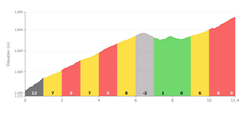
Difficulty breakdown: This HC climb covers 11.4 km and is a serious test because of its high average gradient (7.3%) and its substantial elevation gain (837m). The hard work is concentrated in the first six kilometres, with gradients constantly between 8% and 11%. There is a noticeable breather between km 6 and 9 (gradients from -2% to 1%), before the effort ramps up again over the final three kilometres (gradients from 6% to 9%).
How to manage the effort:
1. Start controlled: Resist the urge to attack the early kilometres (11%) to avoid blowing up too soon.
2. Make the most of the flat: Use the virtually flat section (km 6-9) to recover and refuel before the final push.
3. Save something for the end: The last kilometre averages 9%, so keep some energy in the tank.
According to cyclists' accounts, the road up to Gornyy Kurort Tsey pass is generally in good condition, with good-quality tarmac winding through breathtaking scenery. Even though the last few kilometers before the summit can be a bit more beat-up, the climb is doable without any major issues.
What stands out most for riders is the wild, unspoiled beauty of the place. The clean air, snow-capped peaks, river and forest create an atmosphere of isolation and serenity. The feeling of pedaling through the heart of magnificent nature, far from the crowds of the big-name passes, is a unique experience that comes up again and again.
The vibe is described as authentic and peaceful. Riders point out how relatively quiet the road is, especially outside the busy high-season weekends, which lets you fully enjoy the effort and the scenery. Reaching the top, with the view of the Skazka Glacier (the "Fairy Tale Glacier"), is the highlight of the climb.
For riders who want to push further, it's possible to hike on to the glacier after leaving the bike behind. Accounts do advise coming properly equipped with suitable footwear, though, as the trail is rocky and can be slippery.
11.4 km • 837 m D+
VAM: average climbing speed, based on elevation gain


Join thousands of cycling fans! Plan your rides, record your performance, track your progress and discover the finest climbs.
Live climb profile to pace your effort all the way to the top.

