
Razjerd is a climb of 18.9 kilometers (hors catégorie). Razjerd tops out at 2,324 m above sea level. It is located in دهستان رودبارمحمدزمانی, استان قزوین, ایران. The average gradient is 7.7% with a maximum of 16.1%. The climb has 1452 meters of elevation gain.
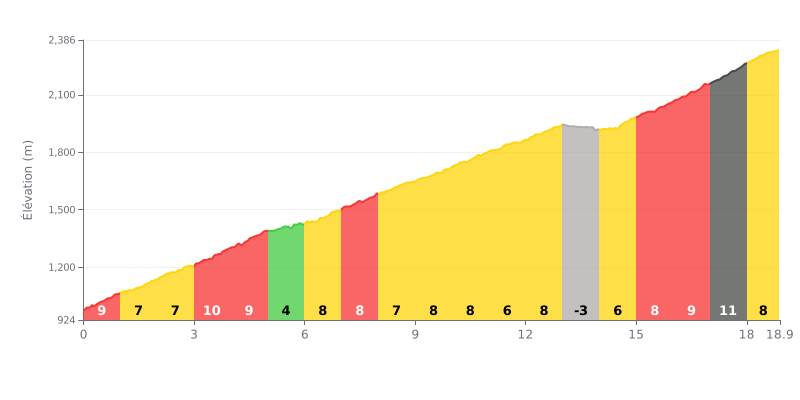
Difficulty analysis: This hors catégorie climb covers 18.9 km and is a demanding effort because of its high average gradient (7.7%) and its substantial elevation gain (1452m). The difficulty is compounded by an uneven distribution: a steep first kilometre (9%), a harder section between km 3 and 4 (10%), and a particularly brutal finish with gradients of 9%, 11% and 8% over the last three kilometres. Kilometre 13 offers a brief respite (-3%), crucial for recovery.
Tips for managing the effort:
1. Pacing: Start conservatively so you don't blow up over the first 4 very steep km. Use km 5 (4%) and km 13 (downhill) to recover actively by easing off slightly without losing your rhythm.
2. Save something for the end: Keep some energy in the tank for the last 3 km, the steepest part of the climb (9%, 11%, 8%). Prepare mentally and physically for this final test.
3. Segmenting: Don't look at the climb as one big block. Break it into sections based on changes in gradient (e.g. km 0-4, km 5-12, km 14-finish) for a more effective mental and physical approach.
18.9 km • 1452 m D+
VAM: average climbing speed, based on elevation gain


Join thousands of cycling fans! Plan your rides, record your performance, track your progress and discover the finest climbs.
Live climb profile to pace your effort all the way to the top.

