
Profitis Ilias is a climb of 12.3 kilometers (hors catégorie). Profitis Ilias tops out at 1,146 m above sea level. It is located in Δήμος Κεντρικών Τζουμέρκων, Αποκεντρωμένη Διοίκηση Ηπείρου - Δυτικής Μακεδονίας, Ελλάς. The average gradient is 8.0% with a maximum of 16.1%. The climb has 984 meters of elevation gain.
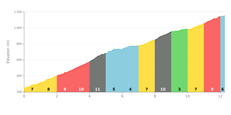
Difficulty breakdown: This 12.3 km climb averaging 8% is hard, rated Hors Catégorie. The real challenge is how uneven it is: three steep sections (KM 3-5 at 10-11%, KM 8-9 at 10%, KM 11-12 at 9%) are separated by flatter stretches (KM 5-7 and KM 9-10 at 3-5%), which breaks your rhythm.
How to manage the effort:
1. Settle into a steady rhythm over the first kilometres (7-9%) so you still have something in the tank before the steepest parts.
2. Anticipate the gradient changes. Use the flatter sections (KM 5-7 and KM 9-10) to recover by spinning an easy gear without stopping, and get ready to dig in for the next ramp.
3. Save something for the finish. The last kilometre (9%) is no joke, so don't blow up on the 11% section (KM 4-5) by overpacing your effort.
12.3 km • 984 m D+
VAM: average climbing speed, based on elevation gain


Join thousands of cycling fans! Plan your rides, record your performance, track your progress and discover the finest climbs.
Live climb profile to pace your effort all the way to the top.


Within 20 km