
Baros Pass is a climb of 21.0 kilometers (hors catégorie). Baros Pass tops out at 1,892 m above sea level. It is located in Χριστοί, Αποκεντρωμένη Διοίκηση Ηπείρου - Δυτικής Μακεδονίας, Ελλάς. The average gradient is 9.6% with a maximum of 17.4%. The climb has 2023 meters of elevation gain.
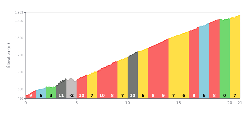
Difficulty analysis: A beyond-category climb that is demanding because of its length (21 km) and high average gradient (9.6%). The difficulty lies in the uneven profile: several stretches at 9-10% (km 3-4, 7-8, 10-11) broken up by short, easier sections or a slight descent (km 4-5), which disrupts your rhythm. The absence of any real respite after km 10 and the finish with a 6% gradient call for disciplined pacing.
Pacing tips:
1. Hold a steady rhythm from the start, and don't overreact to the changes in gradient. Use a constant gear to keep your power steady, especially in the more uneven first kilometres.
2. Save your legs on the moderate sections (like km 2.0-3.0 at 3% or km 19.0-20.0 at 1%) to recover without slowing down too much, ahead of the 10% sections to come.
3. Anticipate the gradient changes by checking the km-by-km profile, especially the sharp ramp to 10% after km 10, so you can adjust your effort and gearing in advance.
According to the cyclists who have climbed it, the ascent of the Baros pass is a one-of-a-kind experience, peaking at almost 1,900 metres above sea level, which makes it the highest paved pass in Greece. Riders describe the feeling of reaching the summit, often above the clouds, as a moment of pure sense of achievement and vastness.
Riders' accounts stress the variety of landscapes along the way: the climb can start in the middle of dense holm oak groves or beech forests before opening onto an almost barren alpine landscape, with jaw-dropping views over the ridges of the Tzoumerka mountains. This dramatic transition is often cited as the highlight of the climb.
Cyclists report that the road surface is generally decent but demands constant attention. Several riders mention loose stones scattered across the tarmac from small rockfalls, as well as sections where the asphalt is broken up or missing altogether. Caution is essential, especially on the technical descents and tight hairpin bends.
The ride also means sharing the road, particularly with plenty of motorcyclists for whom this pass is a must-do. Cyclists also sometimes come across herds of cattle and sheep and their guard dogs on the road, something you need to be ready for. The weather can change completely, with cool temperatures, strong wind or fog at the top, even in the middle of summer.
Despite the challenges, the unanimous feeling among riders is that the effort is well worth it. It's a demanding but unforgettable adventure, offering a real sense of freedom and raw contact with wild, unspoiled nature, an experience that, for many, has nothing to envy in the great Alpine passes.
21.0 km • 2023 m D+
VAM: average climbing speed, based on elevation gain


Join thousands of cycling fans! Plan your rides, record your performance, track your progress and discover the finest climbs.
Live climb profile to pace your effort all the way to the top.

