
Poriya is a climb of 5.3 kilometers (category 3). Poriya tops out at 151 m above sea level. It is located in מועצה אזורית עמק הירדן, מחוז הצפון, ישראל. The average gradient is 2.9% with a maximum of 11.4%. The climb has 156 meters of elevation gain.
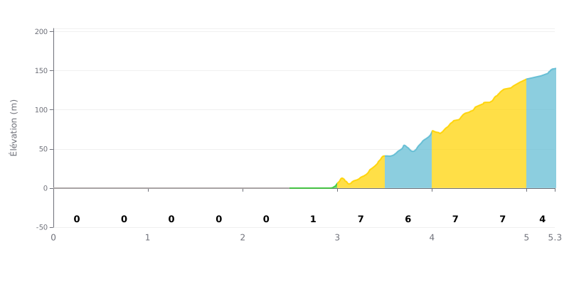
Difficulty breakdown: This 5.3 km climb is unusual. The first 2.5 km are perfectly flat (0% gradient), so it's a long approach. The real difficulty starts after the summit point, with 2.5 km of sustained climbing between 6% and 7% that accounts for most of the elevation gain. The final 300m at 4% offers a bit of respite. The "all or nothing" profile makes the effort mentally and physically demanding.
Pacing tips:
1. Starting out: Use the 2.5 km of flat to warm up and find a smooth, comfortable cadence without going too hard. Don't sprint off the line.
2. Anticipating the gradient change: At 2.5 km, the road kicks up sharply to 7%. Shift into an easier gear early and adjust your effort to hold a steady cadence.
3. Staying focused on the hard section: The 3.0 to 5.0 km stretch is the most demanding. Save something in the tank for the final 300m, which is less steep and gives you a chance to attack before the line.
5.3 km • 156 m D+
VAM: average climbing speed, based on elevation gain


Join thousands of cycling fans! Plan your rides, record your performance, track your progress and discover the finest climbs.
Live climb profile to pace your effort all the way to the top.

