
Kokin Brod climb is a climb of 4.9 kilometers (category 3). Kokin Brod climb tops out at 1,158 m above sea level. It is located in Општина Нова Варош, Централна Србија, Србија. The average gradient is 4.7% with a maximum of 11.2%. The climb has 227 meters of elevation gain.
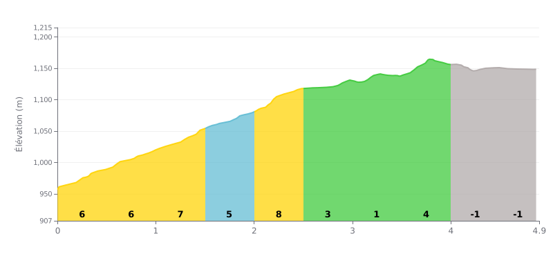
Difficulty breakdown: This Cat 3 climb is moderate. The first half (0-2.5 km) is the hardest, with gradients between 5% and 7%. Things ease off noticeably after that, with an almost flat section (2.5-3.5 km at 2-3%) that gives you a bit of a breather, followed by a short rise before a descent and a flat finish.
Tips for managing the effort:
1. Pacing the steep section: Don't go out too hard. Hold a steady rhythm over the first 2.5 km, where most of the climbing is packed in.
2. Using the breather to recover: Use the flatter stretch in the middle (KM 2.5-3.5) to ease off a little, grab a drink, and get your breathing back under control before the short ramp.
3. Saving something for the finish: The last part is downhill then flat, so you can raise your cadence over the final 500 metres and finish strong.
For cyclists riding the roads around Lake Zlatar, the reward is instant: a jaw-dropping panorama over the deep emerald waters. Riders' accounts agree on the striking beauty of this man-made lake, tucked away between the mountains, which delivers a breathtaking view right from the road.
The experience of approaching the lake is, however, mixed. While one section is easily reached, with a car park and a restaurant for a coffee stop, other riders describe the difficulty of finding a direct, quiet access to the shore. The main road through Montenegro brings traffic noise, and the hairpin descents through the villages can be intimidating, with narrow, steep roads where it is sometimes hard to turn around.
The state of the lake itself varies with the seasons and the years. Several recent reports mention a very low water level, even a lake that is "almost empty" at certain times, which changes the scenery. When the lake is full, boat-taxi trips are mentioned as a unique way to explore the wilder shores.
Caution is advised when it comes to nearby services. Some riders report very negative experiences in restaurants, citing poor service and food of bad quality, something to keep in mind if you're planning a lunch stop.
Despite these challenges, the overall impression is that of a truly special place. For cyclists, Lake Zlatar is much more than a dot on the map: it's a demanding ride destination that, for a bit of effort, offers landscapes that stick in your mind and are really worth the detour.
4.9 km • 227 m D+
VAM: average climbing speed, based on elevation gain


Join thousands of cycling fans! Plan your rides, record your performance, track your progress and discover the finest climbs.
Live climb profile to pace your effort all the way to the top.

