
Čigota is a climb of 9.5 kilometers (category 1). The climb finishes at 1,410 m above sea level. It is located in Ljubiš, n/a, Србија. The average gradient is 6.6% with a maximum of 12.7%. The climb has 625 meters of elevation gain.
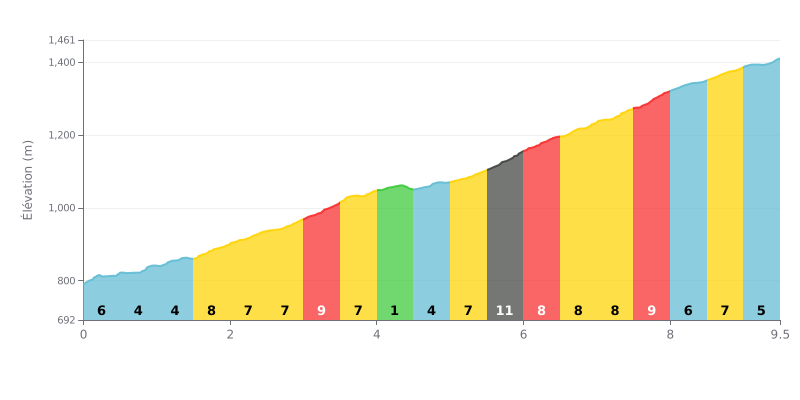
Difficulty breakdown: The Čigota from Vladaje is a tough 9.5 km climb with 625 m of elevation gain, averaging 6.6%, which earns it a Cat 1 rating. The real difficulty is the consistency: almost every kilometre sits between 4% and 11%, with no real break. The hardest part comes between km 5.5 and 8.0, where the gradient stays above 8% over several consecutive stretches, peaking at 11% between km 5.5 and 6.0.
Pacing tips:
1. Don't go out too hard. Don't attack the first half-kilometre at 6% (km 0.0-0.5), then settle into a steady rhythm on the 4% section from km 0.5 to 1.5.
2. Recover at the right time. Use the flatter 1% stretch (km 4.0-4.5) to drink, eat and ease off the pedals before tackling the hardest section.
3. Manage your effort in the final section. Between km 5.5 and 8.0, stick to a smaller gear and a steady effort rather than surging, then take the last 1.5 km (gradients between 5% and 7%) with something still in the tank.
The summit of Čigota, at 1422 m, can be reached by car all the way to the top. Riders report good asphalt, but a narrow road where you need to take it easy. On foot or by bike, some describe a very demanding climb, with a final 250 m section that's steeper and asks for a bit of fitness and a few breaks. One rider advises bringing plenty of water.
The view is the thing that comes up most often. There are no trees at the top, so you can see for miles. On one side you've got Lake Ribnica and Zlatibor, on the other Bosnia and Visoka Banja. Some also claim to spot Durmitor in Montenegro and Ljubiš in Bosnia. The wind blows often, but several riders say it isn't cold, and the air is described as very clean.
Good to know before you set off: the summit is home to a military installation. Access is off-limits, and so is taking photos. Riders usually stop about 50 m below for the view. There's no shop up there, so bring your own shade (a parasol), chairs, drinks and food. A paragliding club is about 400 m below the summit. 4G mobile coverage is available.
Riders describe a quiet spot with no houses around, where you mostly hear the wind and birds. Families with kids spend time there, and one rider found the experience mainly pleasant thanks to the nature on offer.
9.5 km • 625 m D+
VAM: average climbing speed, based on elevation gain


Join thousands of cycling fans! Plan your rides, record your performance, track your progress and discover the finest climbs.
Live climb profile to pace your effort all the way to the top.

