
Kartala is a climb of 26.5 kilometers (hors catégorie). Kartala tops out at 1,443 m above sea level. It is located in Благоевград, Благоевград, България. The average gradient is 4.3% with a maximum of 15.2%. The climb has 1148 meters of elevation gain.
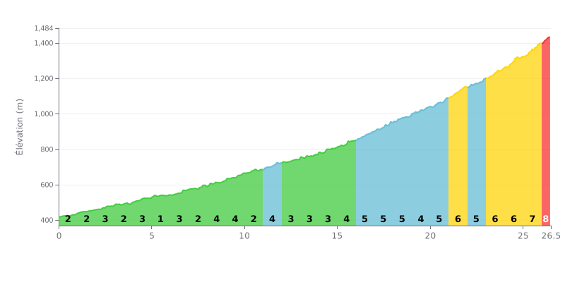
Climb Analysis: This HC climb gets progressively harder. The first 16 km (average gradient of 2.8%) are a demanding but reasonable leg-loosener. Things ramp up significantly after KM 16, with a string of 5-6% ramps peaking at 7-8% over the last 2.5 km. The finale is particularly steep.
Effort Management Tips:
1. Pacing: Resist the temptation to go over your limit early on. The real work doesn't start until past halfway. Use the first part to find an economical rhythm.
2. Save for the Finish: Keep something in the tank for the last 6 km (KM 21-26.5), where the gradient stays above 6% the whole way. This is the most decisive section of the climb.
3. Mental Segmentation: Break the climb into three parts: warm-up (KM 0-16), sustained effort (KM 16-21), and the critical finale (KM 21-26.5). Focus on one section at a time.
According to riders who've climbed it, Mount Kartala is a demanding challenge that calls for a solid level of fitness. Riders describe it as "pretty tough" and a "real test of endurance", with significant elevation gain estimated between 1500 and 1800 meters over a long 25 to 30 kilometers.
The climb is marked by a dramatic change of scenery. The first efforts are made in the heat of the forest, which is best tackled early in the morning. After several hours, riders describe emerging onto an "open alpine meadow" with wide grassy slopes and jaw-dropping views, where the temperature drops noticeably.
Riders stress the importance of preparing properly. Bring plenty of water, at least 4 liters, as there are no water sources along the route. A windproof jacket is also a must, since the summit is described as windy and "pretty cold". Some riders mention dangerous areas, particularly inside the crater.
Despite the difficulty, the effort is unanimously rewarded. Once at the top, riders are greeted by a stunning sight: the huge volcanic crater below and 360-degree panoramas over the Comoros archipelago. This visual reward, this "magical world", makes riders forget the hardship of the climb for everyone who has lived this adventure.
26.5 km • 1148 m D+
VAM: average climbing speed, based on elevation gain


Join thousands of cycling fans! Plan your rides, record your performance, track your progress and discover the finest climbs.
Live climb profile to pace your effort all the way to the top.

