
Jabal Sawda Pass is a climb of 17.4 kilometers (hors catégorie). Jabal Sawda Pass tops out at 2,758 m above sea level. It is located in الشعبين, منطقة عسير, السعودية. The average gradient is 10.1% with a maximum of 16.9%. The climb has 1753 meters of elevation gain.
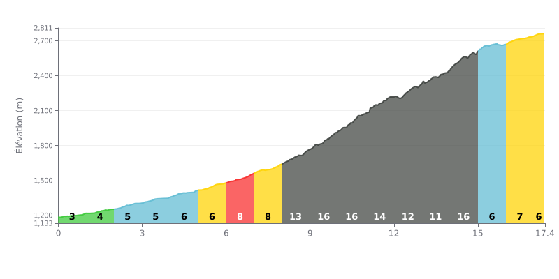
Climb breakdown: This climb has a demanding crescendo profile. The first half (0-8 km) is moderate (3-8%), a gradual warm-up. The real pain starts between km 8 and 15, with a brutal stretch: 13%, 16%, 16%, 14%, then a peak at 17% at km 14. The last part (km 15-17.4) gives some relief at 6-7%, but you'll be hitting it with very tired legs.
Pacing advice:
1. Managing your pace on the middle section: Resist the urge to go too hard in the early kilometres. The goal is to reach the critical section (km 8-15) with something left in the tank. Anticipate the 16-17% ramps and shift down to an easier gear before you get there.
2. Keep a high cadence: On gradients this steep, spinning at a good clip (at least 70-75 rpm) is key to saving your legs and avoiding a lactic burn. Set yourself up with a compact chainset and a big-cog cassette.
3. Break the climb down mentally: Don't think about the full 17.4 km all at once. Focus on getting through one kilometre at a time, especially on the toughest stretch. Use the breather after km 15 to find a steady rhythm and settle in for the run to the summit.
According to the riders who've climbed it, the ascent to the Soudah Mountain Pass Viewpoint is a one-of-a-kind sensory experience. They describe breathtaking scenery, with clouds brushing the road and views stretching over valleys and mountains in lush green. The fresh air and cool breezes, especially late in the day, contrast sharply with the heat down below, creating a calm and invigorating atmosphere.
The road itself is generally described as being in good condition, with quality tarmac that makes the climb pleasant, even for less experienced riders. However, several reports warn of traffic that can be heavy, particularly in summer and at weekends. The road is flagged as being narrow in places, with no shoulder, so caution is needed, especially when fog rolls in and visibility drops.
The vibe at the top is magical, but riders also mention some challenges. The presence of playful monkeys comes up often; drawn by food, they can be pushy, so it's best not to feed them and to make sure vehicles are locked. Some also lament the lack of facilities up there (rest areas, toilets) and point out litter left behind by some visitors, which spoils the natural landscape.
Despite these drawbacks, the overall experience is described as unforgettable. Riders who picked the right time of day, often the afternoon to escape the heat and catch the sunset, highlight the feeling of escape and the deep connection with stunning nature. According to their accounts, it's a climb that stays with you, for the power of its scenery and the surprisingly cool air at the top.
17.4 km • 1753 m D+
VAM: average climbing speed, based on elevation gain


Join thousands of cycling fans! Plan your rides, record your performance, track your progress and discover the finest climbs.
Live climb profile to pace your effort all the way to the top.


Within 20 km