
Al Sahab Park is a climb of 18.5 kilometers (hors catégorie). Al Sahab Park tops out at 2,860 m above sea level. It is located in أبها, منطقة عسير, السعودية. The average gradient is 4.0% with a maximum of 13.7%. The climb has 740 meters of elevation gain.
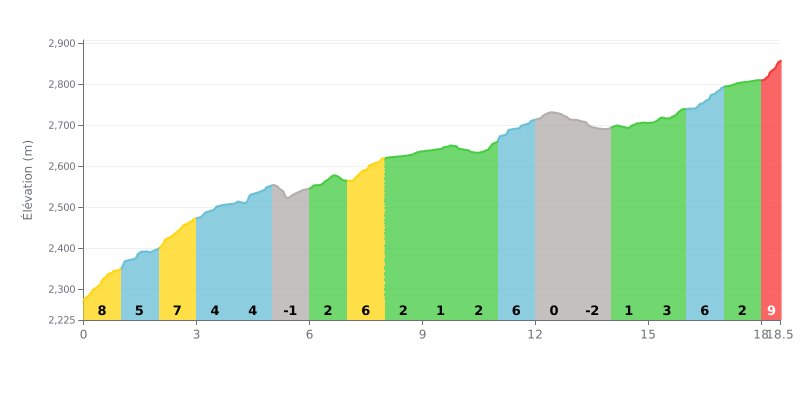
Difficulty analysis: This HC climb is moderate over the distance (18.5 km at 4%), but the profile is very uneven. The difficulty lies in the steep sections at the start (km 0-3 at 7-8%) and at the finish (km 16-18.5 at 6-9%), separated by long flat or downhill stretches (km 5-10 and 12-14) that break your rhythm.
Tips for pacing:
1. Managing the start: Don't go off the deck on the first km at 8%. Settle into a steady rhythm, because an easier section comes next.
2. Anticipating the changes: Use the flat or downhill parts (km 5-10) to recover actively and get ready for the accelerations, especially the demanding finish.
3. Saving something for the end: The last 1.5 km at 9% is crucial. Hit it with something left in the tank by controlling your effort on the gentler slopes before it.
Riders who have climbed Al Sahab Park agree on one thing: the effort is intense, but the payoff is worth it. The climb is described as a demanding ascent, with gradients that push your calves to the limit. It's a test of pure power that appeals to anyone who likes to take on a steep climb.
What makes the ride stand out, according to riders' accounts, is the striking contrast between the effort and the surroundings. The road winds through a barren, arid landscape, with spectacular views of the surrounding mountains. Reaching the summit is often greeted with a real sense of accomplishment, and the breathtaking panorama makes you forget how hard the climb was.
Riders do report, however, that the climb is not a peaceful country ride. Road traffic is a reality, with cars and especially motorbikes sharing the road. This requires constant vigilance from climbers.
Despite this drawback, the overall experience remains memorable. Riders describe a sense of isolation and of pushing through once you're committed to the climb, as if you've left the noise behind for a demanding personal adventure. It's this combination of physical challenge and rugged scenery that makes this climb stick in the memory.
18.5 km • 740 m D+
VAM: average climbing speed, based on elevation gain


Join thousands of cycling fans! Plan your rides, record your performance, track your progress and discover the finest climbs.
Live climb profile to pace your effort all the way to the top.

