
Bum La is a climb of 71.6 kilometers (hors catégorie). Bum La tops out at 4,495 m above sea level. It is located in 喜尔底错, Arunachal Pradesh, India. The average gradient is 7.8% with a maximum of 15.5%. The climb has 5562 meters of elevation gain.
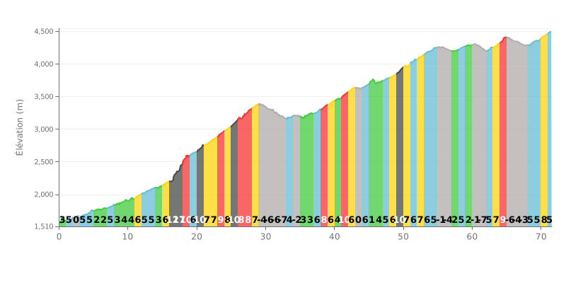
Difficulty breakdown: This 71.6 km climb is a hors catégorie ultra-endurance effort. The 8% average gradient is demanding, but the real challenge is the length and the 5562 m of total elevation gain. The profile is very uneven, with brutal sections (ramps at 12% and 18% between km 16 and 18) and negative sections where you get to recover on the descents (between km 29 and 32, and 61 and 67).
Pacing advice:
1. Ride at a steady power: Hold a consistent effort on the moderate grades (5-7%) to save your energy. Avoid surging on the steep pitches (10-18%), where it's easy to blow up.
2. Make the most of the descents: The negative sections (like km 29-32 and 61-67) are crucial for active recovery and for topping up your fluids without losing time.
3. Break the climb into chunks: Don't think about the 71 km all at once. Focus on 10 km blocks, or on getting through the critical sections (like the km 16-18 stretch at 18%) to keep your head in the game.
For those who have ridden it, Bumla Pass is much more than just a climb. It's an adventure you have to earn, on an unpaved road, through rough, rocky terrain. Riders describe a demanding ascent where the physical grind is amplified by the extreme altitude, over 15,000 feet, and the significant drop in oxygen that can bring on dizziness.
But the effort is more than repaid by jaw-dropping scenery. Riders describe a winding road with panoramic views over colorful lakes and snow-capped mountains, a landscape of raw, untouched beauty. The approach to the pass brings a growing sense of patriotism as you get closer to the Indo-Chinese border.
Reaching the top, at over 15,200 feet, is an intense and humbling experience. Riders mention the bitter cold, often well below zero, and the gusting wind. This is where cyclists meet soldiers of the Indian Army, whose presence and hospitality are consistently praised. They often offer a hot cup of tea and share the history of the place, including the 1962 conflict, which makes the experience deeply moving.
This climb is described as a unique cycling pilgrimage, combining extreme effort, breathtaking landscapes, and a poignant encounter with those who guard the border in such harsh conditions. For many, it's a life-defining experience, far beyond a simple athletic achievement.
71.6 km • 5562 m D+
VAM: average climbing speed, based on elevation gain


Join thousands of cycling fans! Plan your rides, record your performance, track your progress and discover the finest climbs.
Live climb profile to pace your effort all the way to the top.

