
Witzenberg Valley is a climb of 2.9 kilometers (category 3). Witzenberg Valley tops out at 1,056 m above sea level. It is located in Witzenberg Local Municipality, Western Cape, South Africa. The average gradient is 6.3% with a maximum of 13%. The climb has 183 meters of elevation gain.
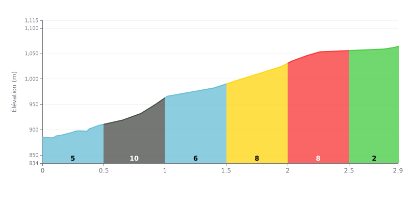
Difficulty breakdown: This 2.9 km climb is rated moderate (Cat 3), but it has one major challenge: a steep kilometer in the middle. The 6.3% average gradient is deceptive. The 0.5 to 1.0 km section at 13% is the hardest part, accounting for more than 25% of the total elevation gain on its own. The final section (2.0 to 2.9 km) is easier at 3-5%, giving you a bit of a breather.
How to manage the effort:
1. Handle the steep ramp: Know where the 13% section starts and don't blow up on it. Keep a steady rhythm so you don't redline your heart rate, and pick a gear that lets you hold a good cadence.
2. Recover on the way to the top: Use the easier gradients over the last few kilometers (3-5%) to get your breathing back under control, then ease back into a bit of extra pace for the finish.
2.9 km • 183 m D+
VAM: average climbing speed, based on elevation gain


Join thousands of cycling fans! Plan your rides, record your performance, track your progress and discover the finest climbs.
Live climb profile to pace your effort all the way to the top.

