
Jaworzyce is a climb of 2.2 kilometers (category 3). The climb finishes at 614 m above sea level. It is located in Węglówka, województwo małopolskie, Polska. The average gradient is 7.0% with a maximum of 12.9%. The climb has 156 meters of elevation gain.
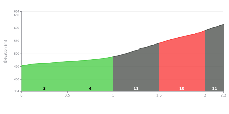
Difficulty breakdown: This 2.2 km climb, with 156 m of elevation gain and an average gradient of 7%, is rated Category 3. The first two sections, KM 0.0-0.5 at 3% and KM 0.5-1.0 at 4%, are fairly easy and let you get your legs turning. The real difficulty starts at KM 1.0-1.5 at 11%, followed by KM 1.5-2.0 at 10% and KM 2.0-2.2 at 11%, so about 1.2 km of sustained gradients back to back with no real break.
Tips for managing your effort:
1. Save something in the tank from the start. On the KM 0.0-0.5 and KM 0.5-1.0 sections, ride at a controlled pace so you hit KM 1.0-1.5 with enough left in your legs.
2. Pick a gear you can spin before the steep section. Choose a gear you can hold while seated through KM 1.0-1.5 at 11%, so you keep a steady cadence.
3. Pace yourself by cadence rather than speed. On KM 2.0-2.2 at 11%, hold a steady power output and don't be tempted to go too hard too early, because the finish is decided by consistency.
Reviews mostly talk about the Przełęcz Jaworzyce, at 579 m, as a starting point. The pass sits on the Little Beskid Trail, and most people use it to start up the red-marked trail towards Lubomir peak, about an hour's walk. At the top there's an astronomical observatory, and information boards along the way explain astronomy, which families seem to like. One reviewer finds the trail easy, another calls it fairly steep at the start.
Parking is small and free. The pass has only a handful of spaces, and one writer mentions about twenty cars in another lot nearby. On weekdays you'll find a spot easily, even at 8:15 am during a long weekend. At weekends it fills up fast: one car park was full by 9:50 am on a nice day. Several people suggest parking a bit higher up, roughly 500 m to 2 km depending on who you ask, where there's another shelter with benches and a proper car park. That saves some of the tarmac road on foot. The approach is on asphalt, shaded at the beginning.
A few negatives come up repeatedly. The road gets traffic from cars driving all the way up, and one person says some overtake walkers on the tarmac section. Another says it smells of exhaust fumes. There's loose stone and gravel on the road surface, and a speed hump across a bend with gravel just after it. Two riders say they came off there, one of them on a motorbike, even though speeds were low. There's also wind in places, and the verge isn't built up, with no real parking area. One person says cars drive up to the inn despite the private road signs, without anyone objecting.
For food, opinions agree: people eat zapiekanki (open-faced grilled baguettes), made at the bar next to the field. One reviewer says they're made to order with the toppings you choose, but only on weekdays. The coffee gets lower marks. There's no year-round food service at the pass, as one person points out.
The views come up often: Babia Góra, the Gorce, the panorama towards Węglówka and Kasina, and Wierzbanowska Góra. One reviewer who spent the night stargazing thinks the spot is great for it. On weekdays, several mention how quiet it is. Few people talk about cycling directly. One writes that it's ideal for riding, another says the descent is straightforward, with no further detail. Most reviews come from walkers and drivers, so keep that in mind.
2.2 km • 156 m D+
VAM: average climbing speed, based on elevation gain


Join thousands of cycling fans! Plan your rides, record your performance, track your progress and discover the finest climbs.
Live climb profile to pace your effort all the way to the top.

