
Crown Saddle is a climb of 9.8 kilometers (category 1). The climb finishes at 1,083 m above sea level. It is located in Wanaka, Otago, New Zealand / Aotearoa. The average gradient is 4.4% with a maximum of 15.5%. The climb has 435 meters of elevation gain.
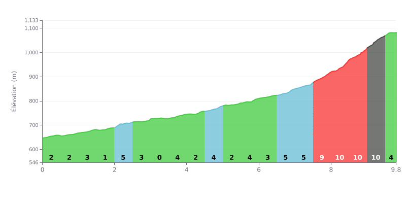
Difficulty breakdown: This first category climb covers 9.8 km for 435 m of elevation gain, for an average gradient of 4.4%. The first part is fairly rolling, with gradients mostly between 2% and 5% and a flat section at 0% from km 3.0 to km 3.5. The final section, from km 7.5 to km 9.5 at 10%, is what will make the difference and be the real decider.
Tips for pacing yourself:
1. Start steady. For the first 6.5 km, ride at a constant pace to keep something in the tank, and use the flat section at 0% (km 3.0 to 3.5) to recover.
2. Prepare for the 10% ramps. Shift into an easier gear before km 7.5 and keep a smooth cadence to tackle the three 10% sections between km 8.0 and 9.5.
3. Finish strong. In the last section (km 9.5 to 9.8, at 4%), push the pace again and crest the summit at full power.
Accounts describe a road that climbs through tight switchbacks up to 1,121 metres, with lots of hairpins and bends. It is sealed, and a sign on site notes that it was only sealed in 2000. Several people mention potholes on the section leading to the summit, and corners where you need to slow right down.
At the top, the viewpoint looks down on Queenstown, Lake Wakatipu and the airport runway, seen from above. Many say they stopped to watch planes come in very low over the valley on approach to town. Some people saw the sunset there, others the sunrise. The car park is large and gravel, and motorhomes often stay the night. There are no toilets and no water. The wind is strong up top, and at night it gets very cold: one traveller recalls waking at 3 a.m. shivering, with snow and ice on the car the next morning.
The descent into Queenstown is the part that comes up most often. The hairpins are tight and the traffic can be in a hurry, with cars going over the speed limit and tailgating. One account advises motorhome drivers to use engine braking, as the brakes heat up quickly. Motorcyclists find the bends very enjoyable when traffic is quiet. Cyclists are flagged as a point of caution for drivers. One cyclist recounts having to push their bike up the last part of the climb, and advises watching out for vehicles and gusts at the summit.
In winter, the road may be closed or require snow chains depending on conditions, and some note that the viewpoint is then not accessible. A walking track leaves from the car park, with a return trip of one to two hours to Rock Point. A few people have also noticed signs about wilding pines, which are spreading into the natural areas of the region.
9.8 km • 435 m D+
VAM: average climbing speed, based on elevation gain


Join thousands of cycling fans! Plan your rides, record your performance, track your progress and discover the finest climbs.
Live climb profile to pace your effort all the way to the top.

