
Magurské sedlo is a climb of 6.4 kilometers (category 2). The climb finishes at 953 m above sea level. It is located in Vojňany, Prešovský kraj, Slovensko. The average gradient is 4.6% with a maximum of 10.9%. The climb has 298 meters of elevation gain.
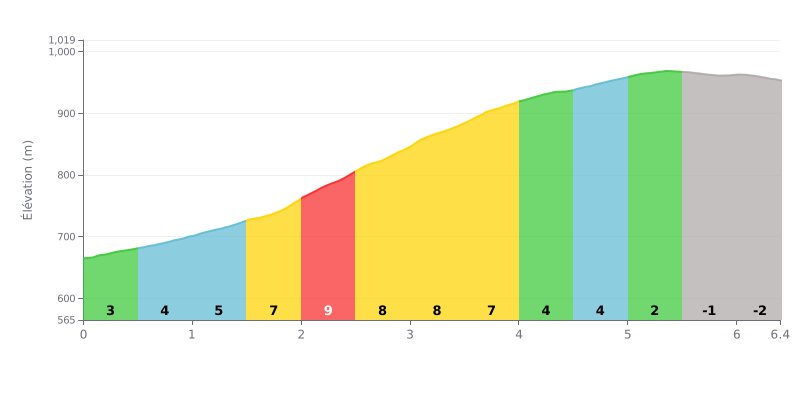
Climb analysis: The Magurské sedlo covers 6.4 km with 298 m of elevation gain and an average gradient of 4.6%, which puts it in Category 2. The hard part is concentrated in the middle section, from km 1.5 to km 4.0, where the gradient varies between 7% and 8%, with a spike to 9% between km 2.0 and km 2.5. The start (km 0.0-1.0) and the end of the climb (km 4.5-5.5) are more rolling, before a descending section between km 5.5 and km 6.4.
Tips for managing your effort:
1. Pace yourself from the bottom. In the first kilometers at 3% and 4%, sit back so you reach the heart of the climb, between km 1.5 and km 4.0, with fresh legs.
2. Prepare for the 9% section. Between km 2.0 and km 2.5, shift into a gear that's easy enough, keep a steady cadence, and avoid going into the red.
3. Use the relative flat. Between km 4.5 and km 5.5, where the gradient eases to 2% or 4%, pick up the cadence and recover before the final effort.
6.4 km • 298 m D+
VAM: average climbing speed, based on elevation gain


Join thousands of cycling fans! Plan your rides, record your performance, track your progress and discover the finest climbs.
Live climb profile to pace your effort all the way to the top.

