
Yaha Pass is a climb of 6.6 kilometers (category 1). The climb finishes at 4,569 m above sea level. It is located in Ville-district de Kangding, 四川省, 中国. The average gradient is 5.3% with a maximum of 12%. The climb has 348 meters of elevation gain.
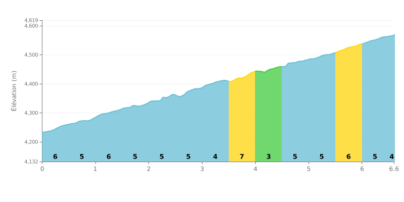
Climb analysis: The 雅哈垭口 from Eku is a Category 1 climb, 6.6 km long with 348 m of elevation gain, at an average gradient of 5.3%. What makes it hard is the consistency: most kilometres sit between 5% and 6%, with no real relief. The toughest section comes between km 3.5 and km 4.0, at 7%. The stretch from km 4.0 to km 4.5, at 3%, is the only real breather on the climb.
Tips for managing your effort:
1. Pace yourself from the start. The opening kilometres at 6% (km 0.0-0.5) tempt you to go out too hard, but you need to save something for later.
2. Prepare for the 7% ramp between km 3.5 and 4.0. Shift into an easy enough gear and stay seated to keep your cadence smooth, then use the km 4.0-4.5 section at 3% to recover.
3. Keep steady over the final kilometres. Hold a consistent rhythm through km 5.5-6.0 (6%) and km 6.0-6.5 (5%), and save your final push until you can see the summit.
6.6 km • 348 m D+
VAM: average climbing speed, based on elevation gain


Join thousands of cycling fans! Plan your rides, record your performance, track your progress and discover the finest climbs.
Live climb profile to pace your effort all the way to the top.

