
Paso Freirina is a climb of 14.9 kilometers (category 1). Paso Freirina tops out at 898 m above sea level. It is located in Vicuña Mackenna, Región de Atacama, Chile. The average gradient is 4.6% with a maximum of 12.5%. The climb has 685 meters of elevation gain.
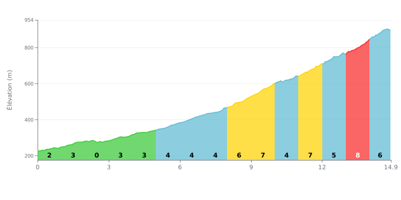
Difficulty breakdown: This Cat 1 climb has a two-stage profile. The first half (KM 0-7) is moderate (gradients of 0 to 4%), a warm-up of sorts. The difficulty ramps up significantly in the second part, with a string of sections at 6%, 7% and even 8% between KM 8 and 14.9. The 4.6% average gradient is misleading; the finale is brutal.
Pacing advice:
1. Manage your pace: Use the first part (gradients under 4%) to settle into a steady rhythm without going into the red. Don't go over the top before KM 8.
2. Prepare for the steep sections: Get ready mentally and physically for the tough stretches (KM 8-9, 9-10, 11-12, 13-14). Keep a smooth, fluid cadence and stay seated to conserve energy.
3. Save something in the tank: The steepest pitch (8%) comes at KM 13. Hold something back so you can maintain your power over the last 2 km.
14.9 km • 685 m D+
VAM: average climbing speed, based on elevation gain


Join thousands of cycling fans! Plan your rides, record your performance, track your progress and discover the finest climbs.
Live climb profile to pace your effort all the way to the top.

