
Kopanec is a climb of 7.4 kilometers (category 3). The climb finishes at 988 m above sea level. It is located in Vernár, Prešovský kraj, Slovensko. The average gradient is 4.3% with a maximum of 5.8%. The climb has 318 meters of elevation gain.
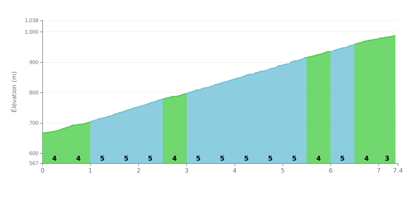
Difficulty breakdown: The Kopanec pass from Vernár covers 7.4 km for 318 m of elevation gain, with an average gradient of 4.3%, which puts it in the 3rd category. There's no truly steep section: each stretch hovers between 4% and 5%, and only km 7.0-7.4 eases off to 3%. The challenge is therefore mostly about holding a steady effort over the duration of the climb rather than a sudden punchy surge.
Tips for pacing yourself:
1. Find a steady rhythm from the start. Don't go out too hard on the km 0.0-0.5 section at 4%, because the gradient stays around 5% from km 1.0-1.5 onward.
2. Manage the long stretches at 5%. Stay seated and pick a gear that lets you keep a smooth cadence between km 2.0-2.5 and km 5.0-5.5.
3. Attack the last section. Km 7.0-7.4, at 3%, gives you a bit of a breather: use it to push a little harder and finish strong.
Reports say this climb is mostly ridden from Podlesok, on a quiet asphalt road. One rider who did an 8-day bikepacking trip, luggage included, describes a climb with no cars, no rollers and a steady gradient. Others say you can also get there from Stratená, where the road is brand new, and that the harder sections are on the Vydrník side.
At the top there's a small tourist shelter that works as a rest stop. From there the view opens toward the Kráľova hoľa, and a forest road heads off toward the Dobšiná Ice Cave. Several riders talk about the nature around, the flower-filled meadows and a quieter spot than the gorge trails, which get packed in season.
Some downsides need mentioning too. The road is officially open to cars, and some riders describe it as a through road with traffic. One rider thinks the descent toward Podlesok would benefit from a proper resurface, as the asphalt is damaged. Another notes that past the sawmill there's a no-entry restriction for private vehicles, except for cabin owners.
On the profile, the descent from the top is about 15 km, with well-banked corners that are a blast on a bike. The climb also suits e-bikes, hikers and runners. A few reviews are very short, but they all praise the setting and the peace and quiet of the place.
7.4 km • 318 m D+
VAM: average climbing speed, based on elevation gain


Join thousands of cycling fans! Plan your rides, record your performance, track your progress and discover the finest climbs.
Live climb profile to pace your effort all the way to the top.

