
Puerto Ahuacales is a climb of 4.2 kilometers (category 2). Puerto Ahuacales tops out at 1,508 m above sea level. It is located in Tula, Tamaulipas, México. The average gradient is 5.7% with a maximum of 16.3%. The climb has 240 meters of elevation gain.
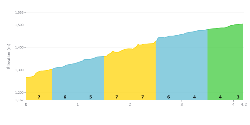
Difficulty breakdown: At 4.2 km, with 240 m of elevation gain and an average gradient of 5.7%, Puerto Ahuacales is a demanding but manageable Cat 2 climb. The hard work is concentrated at the start, with 7% over km 0.0-0.5, then over km 1.5-2.0 and 2.0-2.5. The middle section is easier at 4% over km 3.0-4.0, which gives you a chance to recover before a final 2% over the last 200 meters.
Tips for pacing the effort:
1. Don't go out too hard. The 7% section over km 0.0-0.5 often tempts riders to attack, but a steady pace will save your legs for what's ahead.
2. Keep a smooth cadence on the 7% sections. Over km 1.5-2.0 and 2.0-2.5, stay seated, choose a light gear and avoid surging.
3. Make the most of km 3.0-4.0. With its 4% gradient, this is the time to recover and gradually build up speed before the final 2% stretch over km 4.0-4.2.
4.2 km • 240 m D+
VAM: average climbing speed, based on elevation gain


Join thousands of cycling fans! Plan your rides, record your performance, track your progress and discover the finest climbs.
Live climb profile to pace your effort all the way to the top.


Other climbs to Puerto Ahuacales