
Przełęcz Pod Tułem is a climb of 7.7 kilometers (category 2). Przełęcz Pod Tułem tops out at 580 m above sea level. It is located in Třinec-Líštná, Moravskoslezský kraj, Česko. The average gradient is 3.7% with a maximum of 16.3%. The climb has 286 meters of elevation gain.
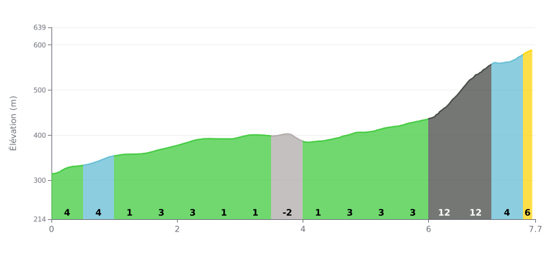
Difficulty analysis: At 7.7 km for 286 m of elevation gain and an average gradient of 3.7%, this Cat 2 climb is a steady, moderate ascent through its first half. The real challenge comes at the finish: kilometres 6.0 to 7.0 average 12% over 1 km, after a long, rolling stretch that can take a lot out of your legs. The 3.0 to 4.0 km section, almost flat and then slightly downhill, gives you a recovery zone to make the most of.
Tips for pacing:
1. Pace the start The first kilometres at 4% (0.0 to 1.0 km) should be ridden at a controlled pace to keep something in the tank for the finale.
2. Make the most of the false flat Between 3.0 and 4.0 km, spin easy, and use the descent to drink, eat and recover.
3. Tackle the steep section calmly Between 6.0 and 7.0 km, at 12%, stay in the saddle, keep a smooth cadence with a gear you can turn over comfortably, then hold your effort all the way to the top on the 5% gradient.
7.7 km • 286 m D+
VAM: average climbing speed, based on elevation gain


Join thousands of cycling fans! Plan your rides, record your performance, track your progress and discover the finest climbs.
Live climb profile to pace your effort all the way to the top.

