
Khulaanklukhamaidan is a climb of 20.1 kilometers (hors catégorie). The climb finishes at 2,388 m above sea level. It is located in Tpig, Дагестан, Россия. The average gradient is 4.1% with a maximum of 12.2%. The climb has 832 meters of elevation gain.
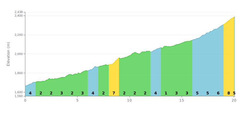
Difficulty breakdown: HC climb of 20.1 km for 832 m of elevation gain at an average gradient of 4.1%. The first 8 km are relatively rolling, with gradients between 2 and 4%, before a steeper ramp at 8% around km 8-9. The real test comes in the final section, from km 16 to km 20, where the gradient goes from 5% to 8% and will really hurt your legs toward the top.
Tips for managing your effort:
1. Pace yourself from the bottom. The km 0-1 section at 4% should be taken at a controlled tempo so you still have something in the tank for a climb this long.
2. Prepare for the 8% ramp at km 8-9. Anticipate this stretch by shifting into an easy gear and keeping a steady cadence.
3. Save something for the finale. From km 16 to km 20, with gradients of 5 to 8%, you'll need enough power left to finish without falling apart.
20.1 km • 832 m D+
VAM: average climbing speed, based on elevation gain


Join thousands of cycling fans! Plan your rides, record your performance, track your progress and discover the finest climbs.
Live climb profile to pace your effort all the way to the top.

