
Alto Gabrielopez is a climb of 4.0 kilometers (category 3). Alto Gabrielopez tops out at 3,225 m above sea level. It is located in Totoró, Cauca, Colombia. The average gradient is 5.1% with a maximum of 15.4%. The climb has 207 meters of elevation gain.
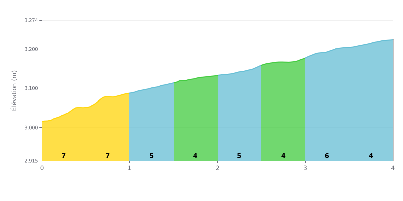
Difficulty analysis: The Alto Gabrielopez has no extreme sections over its 4 km, with an average gradient of 5.1% for 207 m of elevation gain. The start is the hardest part, with 7% gradients over the first two kilometres (KM 0.0-0.5 and KM 0.5-1.0). After that, the road settles between 4% and 5% all the way to the summit. This is a moderate climb, typical of a Category 3, and it comes down mostly to pacing and managing your effort.
Pacing tips:
1. Don't go out too fast on the initial 7%. Settle into a sustainable rhythm from KM 0.0-0.5 so you don't burn through your reserves before the middle section.
2. Hold a steady rhythm between 4% and 5%. From KM 1.0-1.5 to KM 3.0-3.5, keep a constant cadence and use the 4% stretches to recover a little.
3. Save something for the last kilometre. KM 3.5-4.0, at 4%, is manageable: this is the time to lift the pace slightly and finish strong.
4.0 km • 207 m D+
VAM: average climbing speed, based on elevation gain


Join thousands of cycling fans! Plan your rides, record your performance, track your progress and discover the finest climbs.
Live climb profile to pace your effort all the way to the top.

