
Aavasaksa is a climb of 2.9 kilometers (category 3). The climb finishes at 238 m above sea level. It is located in Torniolaakson seutukunta, Lappi, Suomi / Finland. The average gradient is 5.6% with a maximum of 13.8%. The climb has 161 meters of elevation gain.
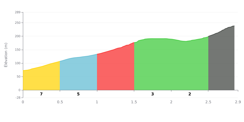
Difficulty breakdown: At 2.9 km for 161 m of elevation gain and an average gradient of 5.6%, the Aavasaksa is a Cat 3 climb that's very doable but still asks a lot of you. The profile is uneven: the first few kilometers bounce between 5 and 9%, with a 9% section between km 1.0 and km 1.5. The stretch from km 1.5 to km 2.5, at just 2%, gives you a real breather before a final push at 11% between km 2.5 and km 2.9, where the accumulated fatigue will hit hardest.
Tips for managing your effort:
1. Pace yourself from the bottom From km 0.0 to 0.5 at 7%, don't go out too hard. Save some legs for the rest of the climb.
2. Recover on the false flat Use the km 1.5 to km 2.5 section, at 2%, to spin up your cadence, drink, and eat something.
3. Tackle the final ramp smartly On km 2.5-2.9 at 11%, shift to an easier gear, stay in the saddle, and keep a steady cadence.
Those who have been to Aavasaksa talk about the view first. From the tower, the landscapes open up far across the Tornionjoki valley, in every direction. Several riders find the evening light the most beautiful, and one visitor saw the midnight sun in the middle of summer. In autumn, the ruska paints the woods, and in spring, the snowmelt is cited as the best time to come.
As for the route, the reports mostly focus on how to reach the summit. Some advise parking at the alppimaja car park, then walking up to the tower, and allowing for the last little climb. The trails are described as well marked, with loops of 0.5 to 4 km, and one rider finds them clean and pleasant to ride. In winter, the snow makes the way more demanding, but another rider did a winter hike and has very fond memories of the view.
On site, there is a restaurant and a café. Feedback on the food is rather positive: the place is clean, calm, the prices are fair and the staff are friendly. One person recommends the savoury waffles from the pavilion. The tower is free, with stairs to climb. For those who want a bit of history, information boards explain the site. You can also ride the royal loop, the "kruununkierros", which several people recommend. There is a campsite, and you can pick blueberries along the way.
The downsides are there too. In summer, mosquitoes are very present. One rider regrets that the old imperial pavilion is in poor condition, at least from the outside. Cabin prices have risen sharply, which makes the stay difficult for the Finns who used to come. One rider simply says they won't go back, without giving a reason.
2.9 km • 161 m D+
VAM: average climbing speed, based on elevation gain


Join thousands of cycling fans! Plan your rides, record your performance, track your progress and discover the finest climbs.
Live climb profile to pace your effort all the way to the top.

