
Chuji Pass is a climb of 8.3 kilometers (hors catégorie). The climb finishes at 628 m above sea level. It is located in Tongchon, 강원도, 조선민주주의인민공화국. The average gradient is 8.4% with a maximum of 14.8%. The climb has 695 meters of elevation gain.
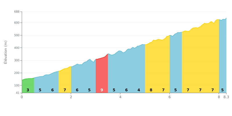
Difficulty breakdown: This HC climb covers 8.3 km for 695 m of elevation gain, an average gradient of 8.4%, which makes it a long and demanding ascent. The hardest section is between KM 3.0 and KM 3.5 at 9%, followed by KM 5.0 to KM 5.5 at 8%. The gradient never drops below 4% and mostly sits between 6% and 7% over most of the route, so you'll be working hard from the bottom to the top.
Pacing tips:
1. Don't go out too hard. The opening kilometres, at 4% from KM 0.0 to KM 0.5, are deceptive: keep a steady cadence so you still have something in the tank for later.
2. Prepare for the 9% section. Between KM 3.0 and KM 3.5, shift to an easier gear and stay seated to hold a smooth cadence without blowing up.
3. Save something for the finish. After the 8% ramps from KM 5.0 to KM 5.5, manage your effort until KM 8.0 to KM 8.3, where the gradient eases to 5% and you can finish strong if you've kept your rhythm steady.
8.3 km • 695 m D+
VAM: average climbing speed, based on elevation gain


Join thousands of cycling fans! Plan your rides, record your performance, track your progress and discover the finest climbs.
Live climb profile to pace your effort all the way to the top.

