
Pratura is a climb of 15.0 kilometers (hors catégorie). Pratura tops out at 1,442 m above sea level. It is located in Tocopilla, Región de Antofagasta, Chile. The average gradient is 9.5% with a maximum of 17.3%. The climb has 1429 meters of elevation gain.
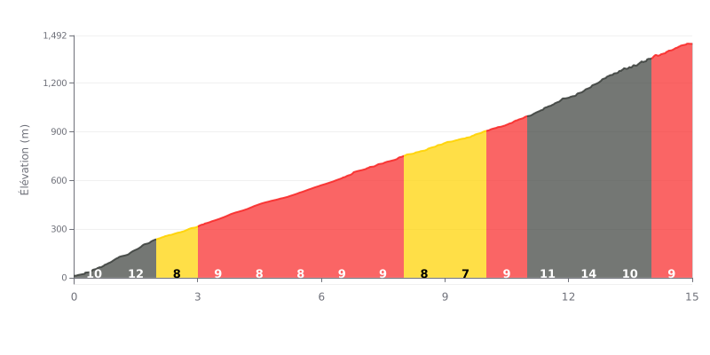
Difficulty analysis: This 15 km climb averaging 9.5% is demanding because of its significant elevation gain (1429 m) and its length, which places it in the HC category. The difficulty is compounded by a particularly steep finish, with gradients of 12% (km 11-12) and 14% (km 12-13), after 12 km of already sustained effort (gradients generally between 7% and 9%).
Pacing tips:
1. Managing your pace on the first section: Resist the urge to go too hard in the opening kilometres (10%-12%) and save your legs for the critical sections at the end.
2. Anticipating the hard finish: Keep some physical and mental reserves for km 11 to 13, the steepest part (12%-14%), where your speed will naturally drop.
3. Holding a steady cadence: Choose a gear ratio that lets you keep a consistent pedal cadence despite the changing gradients, especially on the 8-9% stretches that make up most of the climb.
15.0 km • 1429 m D+
VAM: average climbing speed, based on elevation gain


Join thousands of cycling fans! Plan your rides, record your performance, track your progress and discover the finest climbs.
Live climb profile to pace your effort all the way to the top.

