
Dead Horse Gap is a climb of 6.3 kilometers (category 2). The climb finishes at 1,590 m above sea level. It is located in Thredbo, New South Wales, Australia. The average gradient is 4.0% with a maximum of 15.6%. The climb has 253 meters of elevation gain.
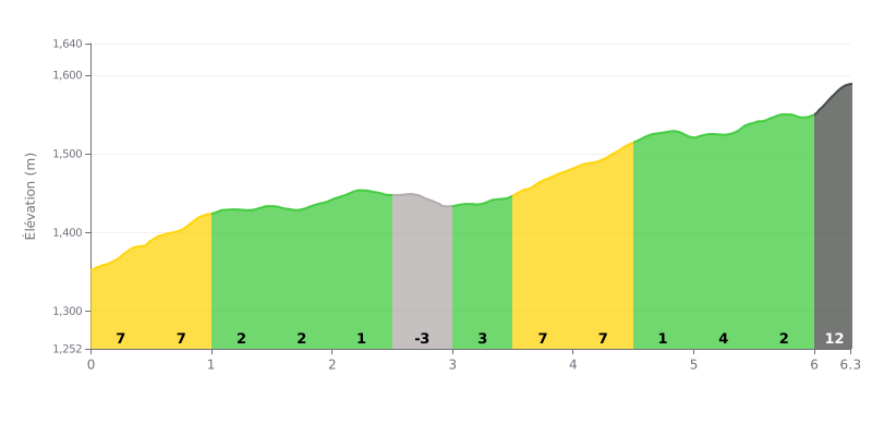
Difficulty breakdown: Dead Horse Gap is a Category 2 climb, 6.3 km long with 253 m of elevation gain, for an average gradient of 4%. The real difficulty is in the gradient changes: the first two kilometres at 8% then 7%, and the 3.5-4.5 km section at 7%, really test the legs. The finale, from km 6.0 to km 6.3 with 12% over 340 m, is where you're most likely to blow up.
Tips for pacing the climb:
1. Don't go out too hard. The 8% then 7% gradients between 0.0 and 1.0 km will tempt you to go deep, so find a strong but sustainable rhythm and keep some reserves in the tank.
2. Recover on the rolling sections. Use the km 1.0 to km 2.5 stretch (1-2%) to recover, top up your fluids and get some food in, then push back on in the short dip between km 2.5 and 3.0.
3. Save something for the finale. After the 7% of km 3.5-4.5, tackle the km 6.0 to km 6.3 section at 12% with a manageable gear and a smooth cadence.
Dead Horse Gap is only a few kilometres from the Thredbo turnoff, along the Alpine Way. The pass crosses the Great Dividing Range at 1580 metres, and several riders say it's probably the highest point on a sealed road in Australia. In summer, people stop there for a break on a holiday drive, with Mount Kosciuszko in view and a bit of snow still on the tops.
In winter, the main road stays open to 2WD vehicles because the gritter keeps clearing it. Further on, the snow is deep. One rider calls it a technical road, and several warn to watch out for traffic, which doesn't really stop up there.
The spot is mostly known for the snow. Families come to go sledding and build snowmen, sometimes when Perisher is full or when the resort has banned sleds. The catch is the limited parking, no toilets, and the crowds on weekends. You also need to dress properly: it gets very cold, and one person recommends protecting your hands and feet. Watch out too for a small pond hidden under the snow, which nearly caught a sledder out.
Reports focus on the views, on both sides of the range when the weather is clear, and on the very clear water and the crisp air. The name comes from the wild horses that died here, trapped in the deep snow of winter. One person even saw skulls along the track. Some people start from here for a short hike on foot or on snowshoes.
6.3 km • 253 m D+
VAM: average climbing speed, based on elevation gain


Join thousands of cycling fans! Plan your rides, record your performance, track your progress and discover the finest climbs.
Live climb profile to pace your effort all the way to the top.

