
Seminskiy Pereval is a climb of 6.8 kilometers (category 2). Seminskiy Pereval tops out at 1,712 m above sea level. It is located in Tenga, Республика Алтай, Россия. The average gradient is 4.7% with a maximum of 8.8%. The climb has 324 meters of elevation gain.
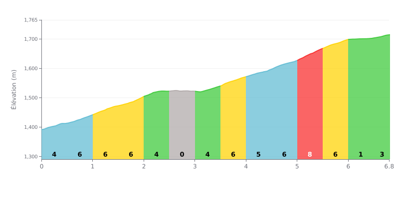
Difficulty analysis: The Seminskiy Pereval is a 6.8 km climb with 324 m of elevation gain, averaging 4.7%, which puts it in category 2. The gradient is fairly steady: most sections sit between 4% and 6%, with a steeper stretch at KM 5.0-5.5 at 8%, which is the hardest point. The flat sections at KM 2.5-3.0 (0%) and KM 6.0-6.5 (1%) give you a bit of relative recovery. Overall, the climb is mostly about holding a steady effort rather than a single explosive effort.
Tips for pacing yourself:
1. Find a steady rhythm from the start In the first kilometres (KM 0.0-0.5 at 4%, then KM 0.5-1.0 at 6%), don't go out too hard so you save something for later.
2. Use the flat to recover At KM 2.5-3.0, where the gradient is zero, drink, eat and ease off the pedals to top up your energy before the second half of the climb.
3. Be ready for the 8% section At KM 5.0-5.5, drop to an easy enough gear, stay seated and keep a smooth cadence to save your legs.
For cyclists, the Semenisky Pass is a major goal: it's the highest point on the Altai road. Riders' accounts describe a demanding climb with the biggest elevation gain in the region, where you need to be careful, especially on the Topuchaya side, as the road can be tough on bikes. But the effort is well worth it.
At the top, the atmosphere is unique, a mix of wild nature and small-scale tourist trade. Riders find food stalls (hot coffee, "pierogis", tea) and souvenir stands, although prices are often considered steep. Some mention basic facilities, like pay toilets in poor condition. The place is more of a quick rest stop than a destination to hang around.
The real magic happens once you get away from the road. Accounts agree on the beauty of the scenery, especially on clear days when you can make out the eternal snows. The pure air of the cedar forest is invigorating. For the more adventurous, heading off onto the gravel tracks toward Mount Sarlyk or the Tuyuk lakes reveals pristine, spectacular nature, far from the crowds.
The experience is also sensory: riders describe a distinct sense of altitude change, with the air feeling "different" above 1500 meters. It can be cold and windy at the top, even in summer, a striking contrast with the valley. It's this encounter with the elements and the wilderness of the Altai that, according to riders' accounts, makes this climb unique and memorable.
6.8 km • 324 m D+
VAM: average climbing speed, based on elevation gain


Join thousands of cycling fans! Plan your rides, record your performance, track your progress and discover the finest climbs.
Live climb profile to pace your effort all the way to the top.


Other climbs to Seminskiy Pereval