
Przełęcz Glisne is a climb of 3.7 kilometers (category 3). The climb finishes at 633 m above sea level. It is located in Tenczyn, województwo małopolskie, Polska. The average gradient is 5.6% with a maximum of 11.7%. The climb has 205 meters of elevation gain.
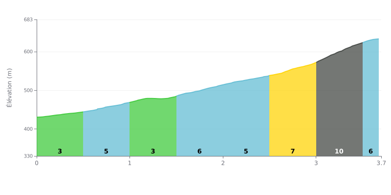
Difficulty analysis: This 3.7 km climb with 205 m of elevation gain averages 5.6%, which makes it a Category 3 climb: a sustained effort, but within reach of any regular rider. The first kilometre, at between 3% and 5%, is a good chance to warm up the legs. The real difficulty is concentrated between 2.5 and 3.5 km, where the gradient ramps up from 7% to 10%, and that section will make the difference.
Tips for the effort:
1. Pace yourself from the start. On the 0.0-0.5 km stretch at 3%, keep a smooth cadence and don't go out too hard, because there's still a lot of climbing ahead.
2. Prepare for the key section. Between 2.5 and 3.0 km (7%) and then 3.0 to 3.5 km (10%), shift into an easier gear, keep a steady cadence and stay focused on your breathing.
3. Save something for the finish. On the final stretch from 3.5 to 3.7 km at 5%, gradually build your effort again without blowing up after the previous steep ramp.
Those who have been through Przełęcz Glisne mostly talk about the pass as a starting point. Two hiking trails cross it: the red one climbs toward Luboń Wielki, the green one toward Szczebel. Several witnesses name Szczebel as the best base. One of them went up in the dark to catch the sunrise, on a well-marked trail.
The area is almost treeless, and the fields around the pass are often flower-filled meadows. There are few people about, the air is clean and it's quiet. The view over the meadow below comes up again and again in the accounts.
Parking is the big weak point. There is almost no proper parking area, and parking is banned nearby, which pushes most people toward a private car park. It costs between 10 and 15 zł according to reports, and the owner is described as friendly. Others have parked on the verge. One witness found a zone that looks like a car park, marked off with tape, but the access isn't passable for low-clearance cars. He also mentions a "private land" sign with no indication of how to pay, by BLIK bank transfer (Polish mobile payment system) to a phone number. Another parked on a patch of ground with a "school bus stop" sign, which was not a road traffic sign.
One witness finds the place lovely but not very set up for visitors. He says so simply, with no further comment.
3.7 km • 205 m D+
VAM: average climbing speed, based on elevation gain


Join thousands of cycling fans! Plan your rides, record your performance, track your progress and discover the finest climbs.
Live climb profile to pace your effort all the way to the top.

