
Pico del Inglés is a climb of 18.2 kilometers (hors catégorie). The climb finishes at 982 m above sea level. It is located in Tejina, Canarias, España. The average gradient is 4.9% with a maximum of 20.6%. The climb has 889 meters of elevation gain.
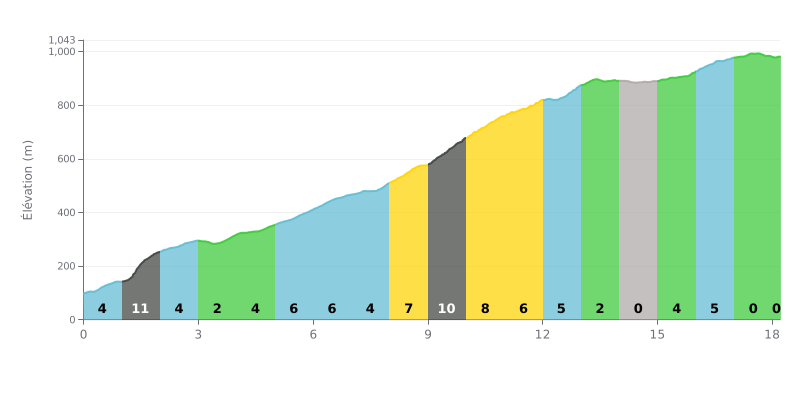
Difficulty analysis: With 18.2 km for 889 m of elevation gain and an average gradient of 4.9%, the Pico del Inglés from Tejina is a long, steady climb, rated hors catégorie. The real challenge is the duration of the effort, as most of the route hovers between 4% and 8%. The steepest sections are km 1.0-2.0 at 11% right from the start, then km 9.0-10.0 at 10%, which comes after more than 8 km of climbing. The flat stretches at km 14.0-15.0 and km 17.0-18.0 do offer welcome breaks, though.
Tips for pacing yourself:
1. Ease into it: On the km 1.0-2.0 section at 11%, resist the urge to go out too hard and aim for a steady cadence from the first pedal strokes.
2. Keep something in the tank over the long haul: On the km 5.0-7.0 section at 6%, pick a gear that lets you spin smoothly without grinding on the pedals.
3. Refuel and recover: Make the most of the nearly flat stretches at km 14.0-15.0 and km 17.0-18.0 (0%) to drink, eat and get your breathing back under control before the final push.
The road climbs up via the TF-12, a mountain road full of bends and switchbacks. Several riders find it stunning but demanding. Some recommend good brakes for the way back down, because it descends hard. Now and then, cars take the corners too fast and end up on the wrong side of the road.
The summit looks out over vegetation-covered valleys and the laurel forest. On a clear day, you can see Teide, Santa Cruz and sometimes Gran Canaria. But the clouds often roll in in bursts, and everything can disappear into fog. Several people say to check the weather before you ride up. It's cool and damp up there, so bring a jacket.
Parking is the weak point. There are few spaces, especially on weekends and around midday, when tourists and rental cars arrive in numbers. Those who got there early in the morning found a spot without any trouble.
Watch out for theft. Several accounts describe cars broken into while people were admiring the view. Bags, phones and documents disappeared within minutes, sometimes after a window was smashed. Don't leave anything visible in the car, close the windows and lock up.
For those who want to hike, trails leave from the summit through the laurel forest. They can be slippery and steep, so wear proper footwear. One rider walked down to Valleseco and found the route very varied, with no tourists.
18.2 km • 889 m D+
VAM: average climbing speed, based on elevation gain


Join thousands of cycling fans! Plan your rides, record your performance, track your progress and discover the finest climbs.
Live climb profile to pace your effort all the way to the top.


Other climbs to Pico del Inglés