
State Hwy 29 pass is a climb of 7.4 kilometers (category 1). State Hwy 29 pass tops out at 495 m above sea level. It is located in Tauranga, Bay of Plenty, New Zealand / Aotearoa. The average gradient is 4.7% with a maximum of 11.8%. The climb has 345 meters of elevation gain.
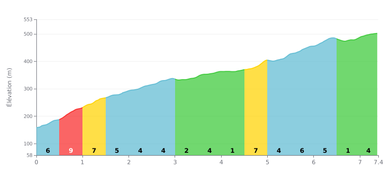
Difficulty analysis: At 7.4 km for 345 m of elevation gain and an average gradient of 4.7%, this first-category climb is demanding but steady. The hardest section comes between km 0.5 and 1.0, with 9% gradients, followed by another tough stretch between km 4.5 and 5.0 at 7%. Between km 3.0 and 4.5, the gradients never exceed 3%, giving you a real breather before the final push. The finish stays honest up to km 6.5 with 5 to 6% gradients.
Tips for pacing the climb:
1. Control the start: Don't get carried away from the bottom, because the road kicks up to 9% between km 0.5 and 1.0. Settle into a rhythm you can hold.
2. Recover on the rolling section: Make the most of the stretch between km 3.0 and 4.5, where the gradient stays below 3%, to recover your legs and get some food and drink in.
3. Manage the final kilometers: Between km 4.5 and 6.5, the 5 to 7% gradients demand a steady cadence. Keep a smooth gear so you have something left for the finish.
7.4 km • 345 m D+
VAM: average climbing speed, based on elevation gain


Join thousands of cycling fans! Plan your rides, record your performance, track your progress and discover the finest climbs.
Live climb profile to pace your effort all the way to the top.

