
Djebel ouarsenis is a climb of 10.2 kilometers (hors catégorie). Djebel ouarsenis tops out at 1,258 m above sea level. It is located in Tamalaht ⵜⴰⵎⴻⵍⵍⴰⵃⵜ تاملاحت, Tissemsilt, Algérie ⵍⵣⵣⴰⵢⴻⵔ الجزائر. The average gradient is 6.0% with a maximum of 17.9%. The climb has 614 meters of elevation gain.
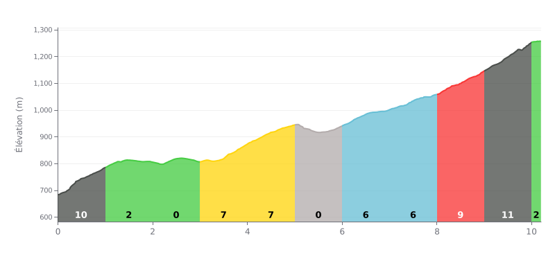
Difficulty breakdown: This HC climb covers 10.2 km with 614 m of elevation gain, at an average gradient of 6%. The opening kilometre is very steep at 10%, then the road alternates between rolling sections and stretches at 6-7% up to the 8 km mark. The finish is the hardest part, with 9% between km 8-9 and 11% between km 9-10, and the flat sections offer little respite.
Tips for managing the effort:
1. Pace the start. On the first kilometre at 10%, ease into it and hold something back for later.
2. Recover on the flats. Use the 0% stretches between km 2-3 and km 5-6 to recover, drink and fuel up.
3. Save something for the finish. Save your legs for km 8-9 and 9-10, where the gradient ramps up to 9% and then 11%, and keep a steady cadence.
10.2 km • 614 m D+
VAM: average climbing speed, based on elevation gain


Join thousands of cycling fans! Plan your rides, record your performance, track your progress and discover the finest climbs.
Live climb profile to pace your effort all the way to the top.


Other climbs to Djebel ouarsenis