
ALTO LA CUCHILLA is a climb of 26.1 kilometers (hors catégorie). ALTO LA CUCHILLA tops out at 3,317 m above sea level. It is located in Sueva, Cundinamarca, Colombia. The average gradient is 5.5% with a maximum of 13.8%. The climb has 1445 meters of elevation gain.
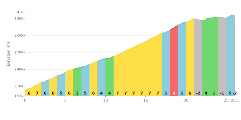
Difficulty analysis: At 26.1 km, with 1445 m of elevation gain and an average gradient of 5.5%, the ALTO LA CUCHILLA is a beyond category climb that demands consistency over its whole length. The first four kilometres, between 5% and 8%, set the tone right away, then a long section at 7% runs from km 11 to km 17. The hardest part is km 18-19 at 9%, near the end of the route. The finale, with the descent at km 21-22 and the almost flat km 23-24, offers a few breathers before the last kilometre at 5%.
Tips for managing your effort:
1. Pace the start Over km 0 to 4, at 7-8%, stay seated and hold a steady rhythm so you don't blow up before the heart of the climb.
2. Make use of the recovery spots Use the 3% stretch at km 6-7 to recover, drink and eat before tackling the long 7% section from km 11 to km 17.
3. Attack the finale At km 18-19, at 9%, shift to an easier gear and keep a smooth cadence, then pick up speed on the false flat at km 23-24 so you hit the last kilometre at 5% in the best possible shape.
According to the riders who have climbed it, the Alto De La Cuchilla is a iconic and demanding climb, a real rite of passage for any cyclist around Bogotá. It's a test of over 11 km, with an average gradient of around 6% that never really gives you a break. For many, it's harder if you're coming up from the capital after already grinding through other passes like Patios or Arepas, which makes it a physical and mental challenge that's among the most rewarding once you reach the summit.
What makes the ride unique is the transformation of the landscape. Riders describe a well-surfaced, quiet road that winds first through beautiful countryside before entering the páramo ecosystem. The final kilometers reveal expanses of frailejones, springs gushing out of the mountainside and, if the weather is clear, a spectacular view over the valleys and the embalse del Tominé.
The experience is, however, shaped by a weather that is unpredictable and often extreme. Riders stress the importance of preparing for intense cold, strong wind, drizzle and fog that can roll in at any moment, especially on the upper section. Proper cold-weather kit (windproof jacket, gloves, warm layers) is considered essential, particularly for the descent where the cold can really bite.
The atmosphere at the top is described as low-key, with little infrastructure, sometimes just a vendor selling hot drinks to warm up with. Riders describe the sense of peace and accomplishment that prevails up there, far from the hustle of the city. Some cyclists, however, lament the lack of respect shown by some motorists and the presence of litter, a reminder of the importance of preserving this natural sanctuary.
In short, for those who have ridden it, climbing La Cuchilla is far more than a simple bike outing. It's an immersive adventure that tests your limits, offers breathtaking scenery and leaves an indelible memory of an effort conquered in the heart of wild, majestic nature.
26.1 km • 1445 m D+
VAM: average climbing speed, based on elevation gain


Join thousands of cycling fans! Plan your rides, record your performance, track your progress and discover the finest climbs.
Live climb profile to pace your effort all the way to the top.

