
Przełęcz Przysłop is a climb of 4.7 kilometers (category 3). The climb finishes at 663 m above sea level. It is located in Stryszawa, województwo małopolskie, Polska. The average gradient is 4.8% with a maximum of 12.3%. The climb has 229 meters of elevation gain.
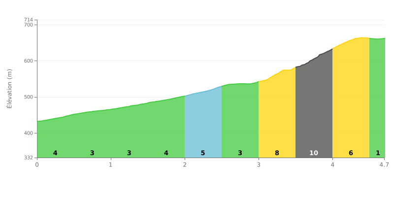
Difficulty breakdown: With 4.7 km at 229 m of elevation gain and an average gradient of 4.8%, Przełęcz Przysłop is a Category 3 climb that most regular riders can handle. The hard part is between km 3 and km 4.5, where the gradient ramps up to 8% and then hits 10% over the 3.5-4.0 km section, after a rolling first half with stretches at 3%. The last section, almost flat at 1% over 4.5-4.7 km, gives you a real breather before the summit.
Tips for the effort:
1. Don't blow up on the opening: over the first 3 km, including the 6% section between 2.0 and 2.5 km, ride at a steady effort so you still have something in the tank for later.
2. Prepare for the 10% section: between 3.0 and 4.0 km, shift into an easier gear, keep a smooth cadence and stay seated to limit muscle fatigue.
3. Kick on in the final stretch: on the nearly flat 4.5-4.7 km at 1%, pick up the pace and push hard to crest the summit with some energy left.
The road to the pass starts from the outskirts of Soblówka, a few kilometres from the village, and most of the climb is on asphalt.
At the summit there is a tourist shelter (wiata). From there, a very steep border trail heads up towards the Wielka Rycerzowa. Another trail, marked in yellow, leads to a shepherd's hut (bacówka) located below the Rycerzowa.
Those who have been up there mostly talk about the calm. They describe a peaceful, picturesque spot where people like to stop for a while.
The reports are brief. They say nothing specific about traffic, about how hard the climb is on a bike, or about resupply.
4.7 km • 229 m D+
VAM: average climbing speed, based on elevation gain


Join thousands of cycling fans! Plan your rides, record your performance, track your progress and discover the finest climbs.
Live climb profile to pace your effort all the way to the top.


Within 20 km