
Whangamōmona Saddle is a climb of 2.8 kilometers (category 1). The climb finishes at 335 m above sea level. It is located in Stratford, Manawatū-Whanganui, New Zealand / Aotearoa. The average gradient is 7.6% with a maximum of 18.4%. The climb has 211 meters of elevation gain.
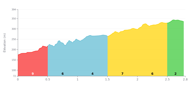
Difficulty breakdown: At 2.8 km for 211 m of elevation gain and an average gradient of 7.6%, the Whangamōmona Saddle earns its Category 1 rating. The start is the steepest section, with 9% over the first 500 m, followed by a more rolling stretch at 5%, then 4% between 0.5 and 1.5 km. The real difficulty comes between 1.5 and 2.5 km, where the gradient stays punchy at 6% to 7%, before easing off noticeably to 2% over the final 260 m.
Tips for pacing the climb:
1. Don't go out too hard. The first 500 m at 9% will tempt you to set too high a pace. Settle into a moderate gear and stay seated to save your legs.
2. Make the most of the 4% section. Between 1.0 and 1.5 km, recover by keeping a smooth cadence so you hit the 1.5-2.5 km section at 6-7% with enough in the tank.
3. Finish strong on the 2% section. Over the final 260 m the gradient eases off clearly: this is the moment to kick on and give it everything you've got left to crest the summit.
Whangamomona Saddle sits on the Forgotten World Highway (SH43), a 149 km road linking Stratford and Taumarunui in the central North Island of New Zealand. Riders describe a twisty road with tight corners and a constant series of climbs and descents. Several say it's a tough ride, narrow in places, and not two lanes all the way.
The most common thread is the scenery: farmland, bush and beech trees lining the road. From the picnic area at the top, on a clear day, you can see Mount Taranaki and Mount Ruapehu. The Moki Tunnel is a single-lane tunnel 180 m long, and several people say riding through it is a memorable moment. Wild goats scramble up the cliffs near Whangamomona, and some riders have counted more than twenty. There's no shade at the picnic area, so come prepared.
On resupply, the reports are clear: there's no café or petrol station over the 148 km. Carry water, food and enough fuel, and you can restock at either end, in Stratford or Taumarunui. The Whangamomona hotel, which used to be a stop, has been closed and on the market since June 2025. There's a campground close to the village.
The downsides come up often. There's car and motorbike traffic on a narrow road, and some sections are still gravel. One witness reports landslips in the farming areas, which they blame on the lack of forest. One person was stuck for seven hours after an alternator failure and a trailer breakdown. Another felt nauseous at the wheel. Most of these accounts come from drivers and motorcyclists, not cyclists, so read the comments on traffic and road condition with that in mind.
2.8 km • 211 m D+
VAM: average climbing speed, based on elevation gain


Join thousands of cycling fans! Plan your rides, record your performance, track your progress and discover the finest climbs.
Live climb profile to pace your effort all the way to the top.

