
Štóske sedlo is a climb of 7.8 kilometers (category 3). The climb finishes at 783 m above sea level. It is located in Štós, Košický kraj, Slovensko. The average gradient is 4.5% with a maximum of 5.7%. The climb has 353 meters of elevation gain.
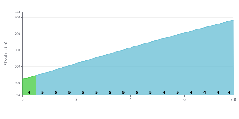
Difficulty breakdown: At 7.8 km with 353 m of elevation gain and an average gradient of 4.5%, the Štóske sedlo is rated Category 3. It's an accessible climb, but it mostly asks for consistency. The effort is remarkably steady: from km 0.5 to km 4.5, the gradient stays at 5% with no respite, and that slowly grinds down your legs. The final kilometers, from 6.0 to 7.8, sit at 4%, which lets you finish a bit more easily, though there's no real recovery there. The main trap is going out too hard on the opening 4% section and blowing up before the long 5% stretch.
Tips for managing your effort:
1. Pace yourself from the start For the first 500 meters at 4%, keep a comfortable cadence so you reach km 0.5 with something left in the tank.
2. Handle the long 5% section Between km 0.5 and km 4.5, go for a moderate gear and a steady rhythm, and stay seated to save your legs.
3. Build up gradually in the final stretch Between km 6.0 and km 7.8 at 4%, gradually raise your effort so you finish strong without emptying the tank.
Those who have ridden it talk a lot about the forest. Some describe a quiet spin under the trees, a pleasant winter ride, and others simply say the nature is beautiful.
The road between Smolník and Štós comes up often. One rider finds it interesting, with switchbacks that appeal to those who like to climb in a beautiful setting. Another calls it excellent, with nice curves and a good view.
At the top, several riders recommend stopping at the small Church of the Apparition of the Virgin Mary. It sits right on the border between two districts. There are also two springs nearby. The view over the Smolník valley is described as fantastic.
The vibe is mostly about the calm. The words that keep coming back are silence, peace and fresh air. One rider writes that it's a place where you find peace, humility and gratitude, and thanks the group for having discovered it. Nobody mentions any particular hassle on the route.
7.8 km • 353 m D+
VAM: average climbing speed, based on elevation gain


Join thousands of cycling fans! Plan your rides, record your performance, track your progress and discover the finest climbs.
Live climb profile to pace your effort all the way to the top.

