
Helshoogte is a climb of 3.3 kilometers (category 3). The climb finishes at 304 m above sea level. It is located in Stellenbosch Local Municipality, Western Cape, South Africa. The average gradient is 5.3% with a maximum of 11.3%. The climb has 176 meters of elevation gain.
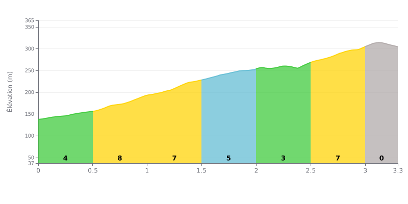
Difficulty breakdown: At 3.3 km for 176 m of elevation gain and an average gradient of 5.3%, the Helshoogte from Stellenbosch is rated Category 3: a climb that's doable but demanding. The hard part is concentrated between km 0.5 and 1.5 and between km 2.5 and 3.0, where the gradient holds steadily at 7%. The 2.0 to 2.5 km section, at 3%, gives you a real breather in the middle of the effort. The final section, slightly downhill (-1%) from 3.0 to 3.3 km, lets you finish without easing off too early.
Tips for managing your effort:
1. Start easy For the first 500 metres at 4%, keep a light spin so you don't burn your matches before the 7% pitches.
2. Settle into the 7% Between km 0.5 and 1.5, stay seated, pick a gear you can hold and favour a steady cadence over mashing the pedals.
3. Recover, then attack Use the 3% section (km 2.0 to 2.5) to catch your breath and save some energy for the 7% stretch from km 2.5 to 3.0.
Seven kilometres, no more. That's how long one reviewer remembers it, and since they ride it for work, they say it makes every trip more enjoyable. The 80 km/h limit, in their view, almost forces you to look up and take in the scenery.
The views come up in nearly every review. People mention the farms around the mountain, Berry Farm, Allee Bleue Estate, and the way the place is laid out. One person writes that you fall in love with the spot if you love nature. Another says the view is worth the detour, and a third simply says it's beautiful.
As for the road, one reviewer describes it as being in excellent condition. The caution they flag is the corners: several people advise taking them carefully. Motorcyclists find the bends fun, and one of them calls it a paradise for bikes.
To be honest, most of these reviews come from drivers and motorcyclists, not cyclists. None of them talk about traffic, noise or litter. One reviewer mentions spring coming on, and another notes the area is also good for paragliding.
3.3 km • 176 m D+
VAM: average climbing speed, based on elevation gain


Join thousands of cycling fans! Plan your rides, record your performance, track your progress and discover the finest climbs.
Live climb profile to pace your effort all the way to the top.

