
Aotou Ling is a climb of 4.9 kilometers (hors catégorie). The climb finishes at 386 m above sea level. It is located in Shangrao, 江西省, 中国. The average gradient is 7.2% with a maximum of 13.5%. The climb has 348 meters of elevation gain.
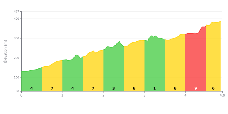
Difficulty analysis: The 鳌头岭 from Lingxiacun is a short but demanding climb: 4.9 km for 348 m of elevation gain and an average gradient of 7.2%, which earns it its HC rating. The difficulty lies mainly in its consistency, with stretches at 7% (KM 0.5-1.0 and KM 1.5-2.0) alternating with more manageable sections. The finale gets much harder, with 9% between KM 4.0 and KM 4.5, while KM 3.0-3.5, at just 1%, is the only real breather.
Tips for pacing yourself:
1. Don't go out too hard. KM 0.0-0.5 at 4% is deceptively easy, and you need to save some legs for the 7% sections that follow.
2. Recover on the flat. Use KM 3.0-3.5 at 1% to drink, eat, and settle back into a steady rhythm before the last part.
3. Prepare for the final push. Save something for KM 4.0-4.5 at 9%, staying seated with a smooth cadence and a light enough gear.
4.9 km • 348 m D+
VAM: average climbing speed, based on elevation gain


Join thousands of cycling fans! Plan your rides, record your performance, track your progress and discover the finest climbs.
Live climb profile to pace your effort all the way to the top.

