
Gardaneh-ye Bijan is a climb of 15.1 kilometers (hors catégorie). The climb finishes at 3,208 m above sea level. It is located in Semirom, استان اصفهان, ایران. The average gradient is 7.7% with a maximum of 18.3%. The climb has 1163 meters of elevation gain.
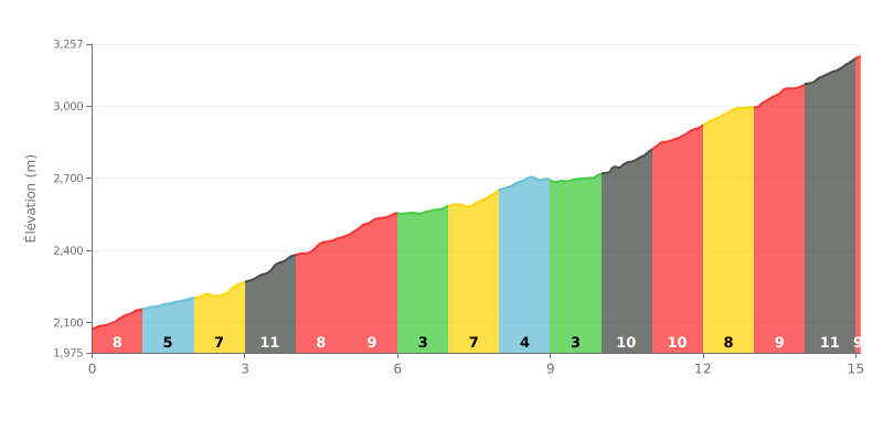
Difficulty breakdown: At 15.1 km, with 1,163 m of climbing and an average gradient of 7.7%, the Gardaneh-ye Bijan from Sheybānī is a demanding HC climb. The real challenge is the steady effort, with no real respite, and stretches at 8% right from the start and several sections at 10% or more. Km 3-4 (11%), km 10-11 (10%) and km 14-15 (11%) are the toughest points, and the finish is decided on very sustained gradients.
Tips for the climb:
1. Pace yourself from the start. Ride at a moderate effort over the first kilometres (8% then 5%) so you still have legs left for the 11% section at km 3-4.
2. Make the most of the easier stretches. The 3% sections (km 6-7 and 9-10) are the perfect moments to recover, drink and fuel up before the hard gradients return.
3. Save something for the end. In the final kilometres (10% at km 13-14, then 11% at km 14-15), pick a gear you can turn over comfortably and keep a steady cadence, without going too hard too soon.
The road runs between the two ranges of the Dena, the eastern Dena and the central Dena, and that's what sticks with anyone who climbs it. Riders describe an asphalt road reaching around 3200 metres, which would make it one of the highest paved roads in the country according to one of them. In the central Dena you'll find the Bizhan 1 and Bizhan 2 peaks.
Timing matters a lot. The road usually opens early in Khordad (late May), and one rider says you can see snow without having to walk to it. It stays open until mid-Mehr (October). One cyclist rates spring as the most beautiful season, while another reckons winter and autumn are the best times. But in winter the snow cuts the road off completely until the road crews clear it, and one report calls winter "unrideable and dangerous".
Those who've done it describe a landscape they find pristine, with small rivers running alongside the road and nomad camps (ʿashāyer) visible from the roadside. Further up there are big green zones, but the trees give little shade. On hot, sunny days the climb is a grind. The air is described as cold. One group pitched their first camp around 3200 metres to prepare for the ascent of the Karmo summit of the Dena.
There are some downsides too. One report flags the risk of unauthorised hunters entering the area to hunt wildlife, and local conservationists stay on alert. Snow and winter conditions are the main limiting factor. The rest of the posts are very brief, just a few words calling the place "beautiful" or "wild", with no more detail about the road itself.
15.1 km • 1163 m D+
VAM: average climbing speed, based on elevation gain


Join thousands of cycling fans! Plan your rides, record your performance, track your progress and discover the finest climbs.
Live climb profile to pace your effort all the way to the top.


Other climbs to Gardaneh-ye Bijan