
Kani Rash is a climb of 9.2 kilometers (category 1). The climb finishes at 2,094 m above sea level. It is located in Sardasht, استان آذربایجان غربی, ایران. The average gradient is 5.2% with a maximum of 13.6%. The climb has 477 meters of elevation gain.
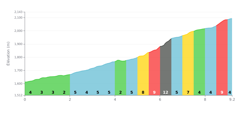
Difficulty analysis: This 9.2 km climb with 477 m of elevation gain and an average gradient of 5.2% deserves its 1st category rating. The first two kilometres, between 2 and 4%, are relatively rolling, but km 2.0-5.0 settles into a sustained gradient of 4 to 5%. The decisive section comes between km 5.0-5.5 (7%) and km 6.0-6.5 (12%), followed by a km 8.5-9.0 stretch at 9% just before the finish.
Tips for managing your effort:
1. Pace yourself from the start: on km 0.0-2.0, at 2 to 4%, stay in a comfortable zone so you reach the middle section with plenty left in the tank.
2. Prepare for the 12% ramp: hit km 5.5-6.5 (9% then 12%) in a low enough gear, with a steady cadence and seated position to conserve your power.
3. Save something for the finale: use the easier stretches of km 6.5-7.0 and km 7.5-8.0 (4%) to recover, then hold something back for the km 8.5-9.0 section at 9%.
Those who've ridden Gardaneh-ye Kani Rash mostly talk about how cold it is up there. The views are great, you can hear the wind, and you'll run into some very real local horses.
On the way, you ride past caves with ice on them and see a waterfall. That's the section that sticks with this rider.
The thing to keep in mind: plan on doing a lot of walking. The rider's report makes light of it, but it's useful info for planning your outing.
9.2 km • 477 m D+
VAM: average climbing speed, based on elevation gain


Join thousands of cycling fans! Plan your rides, record your performance, track your progress and discover the finest climbs.
Live climb profile to pace your effort all the way to the top.

