
El Alto De Cisneros La Quiebra is a climb of 12.7 kilometers (hors catégorie). The climb finishes at 1,557 m above sea level. It is located in Santo Domingo, Antioquia, Colombia. The average gradient is 5.7% with a maximum of 14%. The climb has 728 meters of elevation gain.
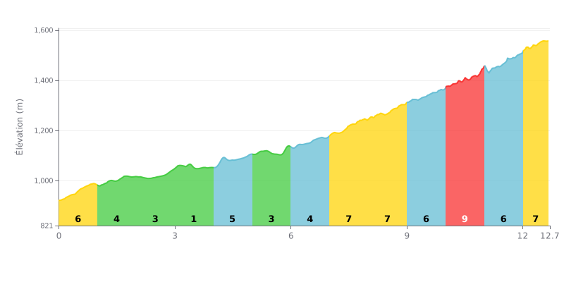
Difficulty breakdown: At 12.7 km for 728 m of elevation gain and an average gradient of 5.7%, El Alto De Cisneros La Quiebra is a serious climb, rated HC (hors catégorie). The difficulty lies mainly in its consistency: almost every kilometre sits between 3% and 7%, with no real respite apart from the flat section at km 3.0-4.0. The toughest part comes in the final stretch, with 9% between km 10.0 and 11.0, followed by 6% and then 7% all the way to the top. So you'll need to manage your effort carefully over the whole climb.
Pacing tips:
1. Don't go out too hard. The first kilometres at 6% from km 0.0-1.0 tempt you to go flat out, so settle into a steady rhythm right from the bottom of the col.
2. Recover on the flat. Use the 0% section at km 3.0-4.0 to drink, eat and loosen up your legs before the second half of the climb.
3. Manage the final. Tackle km 10.0-11.0 at 9% with a small gear, staying seated and smooth on the pedals to hold your power all the way to the summit.
Riders who have climbed the Alto de Cisneros, also known as La Quiebra, have left few words, but they all point the same way: it's an interesting place to check out.
One rider simply says it's an interesting spot to know about. Another is very positive, with a thumbs-up. The last one sums it up in a single word: beautiful.
None of these comments say anything about the gradient, the road surface, the traffic or the scenery. To find out more, you'll have to ride it and see for yourself.
12.7 km • 728 m D+
VAM: average climbing speed, based on elevation gain


Join thousands of cycling fans! Plan your rides, record your performance, track your progress and discover the finest climbs.
Live climb profile to pace your effort all the way to the top.


Other climbs to El Alto De Cisneros La Quiebra