
Morro Itatiaia is a climb of 10.2 kilometers (category 1). The climb finishes at 966 m above sea level. It is located in Santa Rita do Passa Quatro, São Paulo, Brasil. The average gradient is 4.0% with a maximum of 19.6%. The climb has 409 meters of elevation gain.
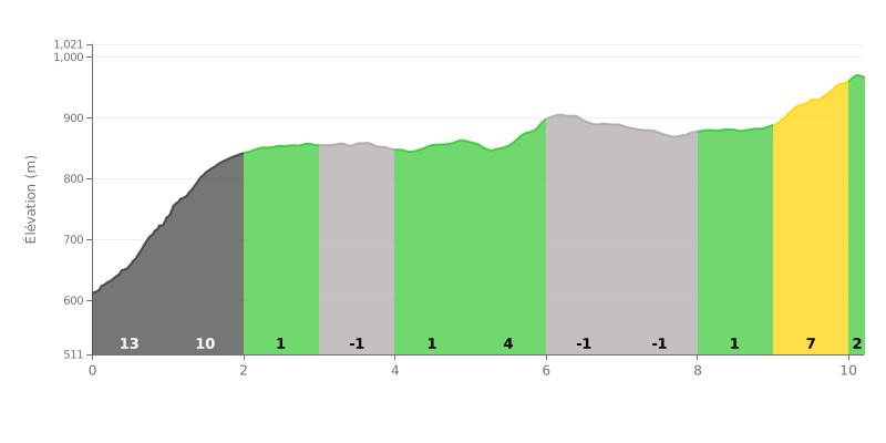
Difficulty breakdown: Over 10.2 km for 409 m of elevation gain, the Morro Itatiaia averages a 4% gradient, which looks moderate on paper. The real difficulty is concentrated in the first two kilometers, with 13% and then 10% ramps that eat up a big chunk of the climbing. The final part of the ascent, with 7% between km 9.0 and km 10.0, is still tough on legs that are already tired.
Pacing tips:
1. Don't go out too hard. On the km 0.0-1.0 section at 13%, dial back your effort so you still have something left for what comes next.
2. Use the false flat. Between km 2.0 and km 5.0, where the gradient hovers between -1% and 1%, recover and find a steady rhythm again before the hardest part.
3. Save something for the end. Keep some energy for the 7% section between km 9.0 and km 10.0, then for the final stretch at 2% to the finish.
The viewpoint sits at the top of Morro do Itatiaia, at km 6 of the Estrada Vicinal Alciro Ribeiro Meirelles. People who've made the trip talk about a really beautiful view over the area. From the lookout, you can make out several towns, including Tambaú, Porto Ferreira and Pirassununga.
At the summit stands a 22-meter-tall statue of Christ the Redeemer. It's the finish point for several pilgrimages, including the Caminho da Fé.
As for the facilities, the feedback is good. The place is well run, clean, and the infrastructure seems built to handle a crowd. One rider especially enjoyed the lunch and the staff, described as very polite and helpful.
Heads up: several people report that the site is closed on Mondays and Tuesdays. One of them made the trip on a Tuesday and found the access closed. Best to check the opening hours before you head out.
A visitor who has been coming here for decades says it has improved a lot. The reviews are mostly about the place and the view. They say very little about the road itself: the gradients, the surface condition and the traffic aren't mentioned. You'll need to make your own call on that one.
10.2 km • 409 m D+
VAM: average climbing speed, based on elevation gain


Join thousands of cycling fans! Plan your rides, record your performance, track your progress and discover the finest climbs.
Live climb profile to pace your effort all the way to the top.

