
Alto Tinajas is a climb of 4.2 kilometers (category 3). Alto Tinajas tops out at 343 m above sea level. It is located in Santa Marta, Magdalena, Colombia. The average gradient is 4.9% with a maximum of 16.6%. The climb has 205 meters of elevation gain.
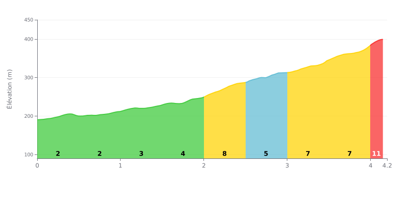
Difficulty breakdown: At 4.2 km for 205 m of elevation gain and an average gradient of 4.9%, the Alto Tinajas is rated Category 3 and calls for a solid aerobic base. The first two kilometres, between 2% and 4%, are relatively rolling and give you time to find your rhythm. The real difficulty comes from the 2.0-2.5 km section at 8%, then the 3.5-4.0 km stretch at 8% and the 4.0-4.2 km section at 9%, which are the most demanding parts.
Tips for managing your effort:
1. Stay steady from the start. Over the first 2 kilometres (between 2% and 4%), ride at tempo and don't go off too hard so you save some legs for what's coming.
2. Prepare for the 2.0-2.5 km ramp. Shift to an easier gear before the 8% section and keep a smooth cadence rather than mashing a big gear.
3. Pace the final part of the climb. Between 3.5 and 4.2 km (8% then 9%), hold something back for the finishing effort and don't surge too early.
4.2 km • 205 m D+
VAM: average climbing speed, based on elevation gain


Join thousands of cycling fans! Plan your rides, record your performance, track your progress and discover the finest climbs.
Live climb profile to pace your effort all the way to the top.

